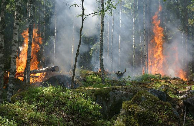
The fire in the forests carries a terrible disaster. In forest fires, many trees die every year, insects, birds, animals suffer. Entire villages and outskirts of small towns burn out. Often there are cases of death. Not to mention the environmental disaster. After all, forests are the "lungs" of our planet.
Forest fire flares up extremely quickly, spreads at lightning speed and exposes the entire territory of the forest to complete or partial destruction. There were cases when a fire in Russia spread to the territory of China and Mongolia. It is very difficult to control the elements, therefore, a number of departments have been created that are involved in the study and monitoring of forest fires. Extinguishing is also controlled, and scales such as forest vegetation in the area are created.
Why do forest fires occur?
Sometimes fires occur due to a human factor: vacationers in the forest threw a cigarette butt on the grass or forgot to completely extinguish the fire. Even a left glass bottle can work in the sunlight like a lens, ignite dry grass and cause forest fires. For logging workers it is important to comply with fire safety standards, as they often use fuels and lubricants for equipment.
On the fields after harvesting remains grass, which is often burned out. With a strong wind, a fire can spread to a nearby forest. Sometimes residents of nearby villages can burn trash in the place where peat bogs are underground. There is also a deliberate arson of the forest by entrepreneurs, who subsequently rely on deforestation.
There are a number of other natural causes of forest fires. In the hot dry season, dead wood may inflame in the sun or peat bogs may spontaneously ignite. During a severe thunderstorm, trees light up from a lightning bolt. Fire from them accounts for about 8% of all emerging environmental disasters.
Fire Detection Methods
One of the most effective ways to monitor forest fires is satellite observation from space, photographing the area in infrared light. They show areas of very high temperature, which can outline the zone of fire. Data processing is performed using sophisticated electronic equipment. Also, satellite information can be additionally obtained on meteorological conditions in the study area, the strength and direction of the wind. Data is updated 4 times a day.
Services sometimes turn to American counterparts or private satellite owners for help. Their shooting is more accurate, but, of course, more expensive. Also, the fire zone is not always correctly determined, since a circle of a larger diameter is outlined. The high smoke density of the territory interferes with the accuracy of detection. To correctly identify the area of fire, to determine the fire hazard class, you need to connect other methods.
As additional means of obtaining information, one can name forest monitoring from air transport. Currently, drones are actively used, which make a video of the terrain from the air. Also in the forests established observation posts. These are towers standing at a distance of several kilometers from each other.
In addition to observers, they are equipped with video cameras and communications equipment. However, there are personnel problems, as the number of foresters has been reduced, and the remaining people simply do not have time to physically collect enough complete information. And the cameras are directed only in one direction, and this does not always live up to expectations. Cellular towers are also used for monitoring, on which cameras and sensors are installed that show an increase in air temperature, thermal imagers.
Hazard rating
The Order of the Federal Forestry Agency dated July 5, 2011 "On Approving the Classification of Natural Fire Hazards of Forests and the Classification of Fire Hazards in Forests Depending on Weather Conditions" gives an exact definition of the degree of fire hazard in forests, of which there are five in total. Depending on the type of afforestation, species and quality of trees, the presence of dead wood and peat bogs, young shoots and density, a table is built from which it can be concluded in what area a fire can be expected and what kind of force the flame will rage.
The highest class is assigned to forest strips with coniferous young trees. Here, in the fire hazard season, both ground and horse fires of varying degrees of complexity are always expected. Strips with planted pine trees, lingonberries, cedar trees or larch trees are given a fire hazard class 2 in the forests. In such places during the season there is a high probability of ground fires, that is, from 0.5 to 1.5 m. To the tops the fire rises extremely rarely, and even then in the case of maximum flame during severe drought and gale.
These fire hazard classes in forests account for almost 80% of all fires observed in the Russian Federation. The remaining three are not difficult to extinguish, occur much less frequently and are extinguished faster. Before determining the class of fire hazard in forests, a forestry survey of planted areas is carried out, data is recorded and processed by special departments.
Federal scale for assessing natural hazard
Throughout Russia, a natural indicator of the danger of fires is also calculated. It depends on air temperature, meteorological conditions. In places of severe drought, there is a high probability of fire. Fire services every day, at 12 o’clock, the coefficient of natural fire hazard of forests is calculated.
The following data are taken for calculation: air temperature on a given day, number of days without rain and dew point. The counting of days begins from the last rainy day, when precipitation was up to 3 mm. Calculate the formula and the coefficient of natural hazard. The result is up to 300 units - there is no possibility of fire, an indicator of more than 10,000 units indicates an extreme danger.
Types of Forest Fire
Depending on the height of the flame above the ground, there are three types of fires in forests. The lowest is the underground view. The ignition of underground peat deposits from high density and elevated air temperature is moving slowly, several meters a day. But since peat deposits are at a depth of up to 50 cm, it is extremely difficult to extinguish such a fire.
The downstream type of flame spread in the forests reaches a maximum height of 1.5 m. Dry grass, steamed vegetation, young trees light up. In such a fire, not only the burrows of animals with cubs, but the roots and layer of the bark of large trees can be affected. And this leads to their death. Also, such a fire can surprise people in the forest.
The top view of a forest disaster is characterized by an extraordinary flame height. It sometimes reaches 120 meters. With such a flame, large centuries-old trees die, their crowns and trunks burn out. The wall of fire moves with high wind at high winds. Due to the thickness of the trunks, it is very difficult to extinguish such a fire.
Reduce forest loss during fires
Various preventive measures are carried out throughout the year. In accordance with the fire hazard classes in the forests, parameters are measured to calculate the coefficient of a possible threat. The growth of trees, the appearance of coniferous undergrowth is being monitored. Fire fighting methods are also accepted. The so-called flame barriers are created, which are partially or in stripe-cut sections; sanitary felling is carried out in forests.
Fire safety points are equipped. Fires or their strong spread can be avoided when foresters closely monitor the growth of young animals, clean the area from dry shrubs and old trees, and control over deadwood. Mineralized stripes of land are also laid for the same purpose, at a distance of 50 meters. Several of these strips are fully capable of preserving the forest and protecting it from the spread of fire.
Fire localization activities
First you need to detect a fire. After information about a fire has been received from a satellite, it is necessary to accurately determine and, if possible, narrow down its searches on the spot. To do this, use air transport: airplanes, fire helicopters, drones. Of great importance is the speed with which the fire area was discovered and extinguishing measures were organized. Equally important is the preparedness of all fire departments in the region.
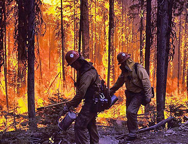
The second important step in extinguishing a fire is its localization. Barrier barriers must be put up on all sides. This is done so that the fire could not spread to other parts of the forest, nearby settlements, enterprises. First, the edge of the fire strip is watered by firefighters, a wet strip of land is created, the trees are moistened. Also, with the help of technology, plowing of land strips, cleansing of the nearby territory from shoots and trees are performed. When these measures are carried out around the flame from all sides, it means that a forest fire is localized.
Fire extinguishing
After complete localization of the site begins, in fact, the elimination of the source of combustion. Fire extinguishing is carried out using ground and air fire extinguishing means. Ponds located close to the fire are used. Special equipment flies up to them and scoops up water with buckets. Then, moving over the conflagration, he releases it into the burning forest.
The last stage in extinguishing is considered to be the bailout of the territory affected by the fire. Firefighters carefully inspect the disaster area in case of re-ignition. This must be done for a long period of time until the understanding of complete safety. Meteorological conditions are also taken into account. The focus is on the edges.
Additional measures
In the event of a severe fire, when a high fire hazard class is recorded, chemical extinguishing agents are used and artificially cause rain in the clouds. On the ground, around the fire, pour dry soil on the edge. If there are a lot of human resources, then along the perimeter there are people with large branches and engulf the fire. They can also bake the edges by making an empty strip. Sometimes in severe cases, oncoming ground or horse fire is connected .
How to get out of the danger zone?
If a person finds himself in a forest or next to peat bogs at the wrong time when a fire started, then in no case should you panic. First of all, it is necessary to determine the direction of the wind and move in the windward direction. Breathing organs must be covered with a wet towel or any part of the clothing.
If you know that a pond is located nearby, then you need to immediately move in its direction. When peat burns underground, you need to advance with a pole in your hand, carefully probing the soil under your feet. The fire can smolder below, and it will be very unpleasant to fall into a burning hole.
Work with the population
People living near forests prepare for fires in advance. Preventive outreach is underway. If a fire starts, the population is urgently evacuated. Take with you recommend only the most necessary.
If it was not possible to get out, then you need to close the room without open ventilation hatches. You can hide in the cellar. Carry water, wet bedspreads and towels. If the fire caught on the ground, then you can not be among the trees. You need to get out in the field, close the respiratory system.
It also instructs people involved in stewing. Do not pour water on electrical installations and wires. There should be no equipment in the firing point. Completely block the passage to the danger zone.