The Dardanelles is a strait between the northwestern part of Asia Minor and the Gallipoli Peninsula, located in the European part of Turkey. The Dardanelles Strait, whose width is from 1.3 km to 6 km and a length of 65 km, is of great strategic importance, as it is part of the waterway connecting the Mediterranean Sea with the Black Sea.
Gella Sea
The outdated name of the strait is the Hellespont, which is translated from Greek as "the sea of Gella." This name is associated with the ancient myth of twins, brother and sister, Frix and Gella. Born by the Orkhomeni king Afamant and Nefela, the children were soon left without a mother - they were raised by the evil stepmother Ino. She wanted to destroy her brother and sister, but the twins escaped on a flying ram with golden wool. During the flight, Gella slipped into the water and died. The place where the girl fell - between Chersonesos and Segay - has since been called the "Sea of Gella." The Dardanelles Strait received its modern name from the name of the ancient city once standing on its shore - Dardania.
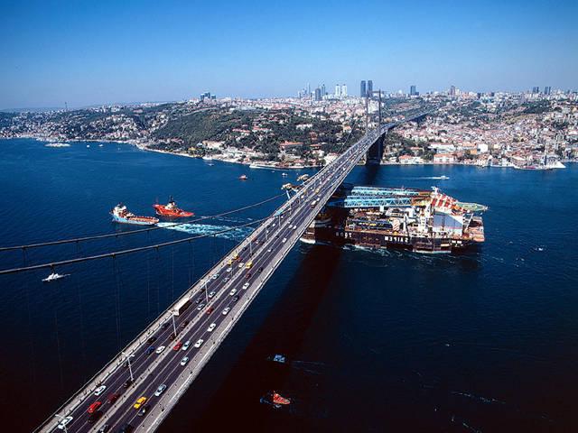
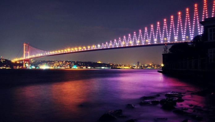
Bosphorus
This is another Black Sea strait. The Bosphorus connects the Black Sea with the Marmara. The strait has a length of approximately 30 kilometers, its width ranges from 700 m to 3700 m. The channel depth is from 36 to 124 m. Istanbul (historical Constantinople) is located on both sides of the strait. The shores of the Bosphorus are connected by two bridges: the Bosphorus (length - 1074 meters) and the Bridge of the Sultan Mehmed Fatih (length - 1090 meters). In 2013, in order to unite the Asian and European parts of Istanbul, the Marmaray railway submarine tunnel was built.
Geographical position
The Dardanelles and the Bosphorus are 190 kilometers apart. Between them is the Sea of Marmara, whose area is 11.5 thousand km2. A sea vessel going from the Black to the Mediterranean Sea must first enter the rather narrow Bosphorus, pass Istanbul, swim to the Sea of Marmara, after which he will meet with the Dardanelles. This strait ends with the Aegean Sea, which, in turn, is part of the Mediterranean. In its length, this path does not exceed 170 nautical miles.
Strategic importance
The Bosphorus and Dardanelles are links in the chain connecting the closed sea (Black) with the open (Mediterranean). These straits have repeatedly become the subject of controversy between the leading world powers. For Russia in the 19th century, the path to the Mediterranean Sea provided access to the center of world trade and civilization. In the modern world, it is also important, is the "key" to the Black Sea. The international convention suggests that the passage of merchant and military vessels through the Black Sea straits should be free and free. However, Turkey, which is the main regulator of traffic through the Bosphorus, is trying to use this situation in its interests. When oil export from Russia increased significantly in 2004, Turkey sanctioned the restriction of ship traffic in the Bosphorus. There were traffic jams in the strait, and oil industry workers began to incur all kinds of losses for failure to meet delivery deadlines and for idle tankers. Russia officially accused Turkey of deliberately complicating the movement on the Bosphorus with the aim of redirecting the export cargo flow of oil to the port of Ceyhan, whose services are paid. This is not Turkey’s only attempt to capitalize on its geophysical position. The country has developed a project for the construction of the Bosphorus Canal. The idea is good, but the Republic of Turkey has not yet found investors to implement this project.
Fighting in the region
In antiquity, the Dardanelles Strait belonged to the Greeks, and Abydos was the main city in the region. In 1352, the Asian coast of the strait passed to the Turks and Canakkale became the dominant city.
According to an agreement concluded in 1841, only Turkish warships could pass the Dardanelles. The First Balkan War put an end to this state of things. The Greek fleet defeated Turkish at the entrance to the straits twice: in 1912, December 16, during the battle at Elli, and in 1913, January 18, at the battle of Lemnos. After that, the Turkish fleet did not dare to leave the strait anymore.
During the First World War, the bloody battles between Atlanta and Turkey were fought for the Dardanelles. In 1915, Sir Winston Churchill decided to immediately knock Turkey out of the war, breaking through to the capital through the Dardanelles. The first Lord of the Admiralty was deprived of military talent, so the operation crashed. The campaign was poorly planned and mediocre. In one day, the Anglo-French fleet lost three armadillos, the rest of the ships were seriously damaged and miraculously survived. The landing of fighters on the Gallipoli Peninsula turned into even greater tragedy. 150 thousand people died in a positional meat grinder, which did not bring any results. After the Turkish destroyer and the German submarine sank three more British battleships, and the second landing in the Suvla Bay was ingloriously defeated, the military operation was decided to be curtailed. A book was written about the circumstances of the greatest catastrophe in British military history, entitled "The Dardanelles of 1915. Churchill's Bloodiest Defeat."
Question of the Straits
While the Byzantine and then the Ottoman Empire dominated the area of the Straits, the question of their functioning was decided within the states themselves. However, at the turn of the 17-18 centuries, the situation changed - Russia entered the coast of the Black and Azov Seas. The problem of control over the Bosphorus and Dardanelles has risen on the international agenda.
In 1841, at a conference in the city of London, an agreement was concluded that the straits would be closed to the passage of warships in peacetime. Since 1936, according to modern international law, the Straits zone has been considered the “open sea” and questions about it are regulated by the Montreux Convention on the Status of Straits. Thus, control over the straits is carried out while maintaining the sovereignty of Turkey.
Montre Convention
The Convention states that merchant ships of any state have free access to pass through the Bosphorus and Dardanelles in both wartime and peacetime. The Black Sea powers can navigate through the straits military vessels of any class. Non-Black Sea states can only let small surface ships pass through the Dardanelles and the Bosphorus.
If Turkey is involved in hostilities, the country may, at its discretion, allow warships of any power to pass. During the war, to which the Republic of Turkey is not related, the Dardanelles and the Bosphorus should be closed to military courts.
The last conflict in which the mechanisms stipulated by the Convention were involved was the South Ossetian crisis in August 2008. At this time, US Navy warships passed through the straits, which proceeded in the direction of the Georgian ports of Poti and Batumi.
Conclusion
The Dardanelles Strait on the map of Eurasia takes up very little space. However, the strategic importance of this transport corridor on the continent is difficult to overestimate. From an economic point of view, for Russia, the export of petroleum products is important. Transportation of "black gold" by water is much cheaper than by pipeline. Every day 136 ships pass through the Dardanelles and the Bosphorus, 27 of them are tankers. The traffic density through the Black Sea straits is four times higher than the intensity of the Panama Canal, three times higher than the Suez Canal. Due to the low passability of the straits, the Russian Federation incurs losses of approximately $ 12.3 million daily. However, a worthy alternative has not yet been found.