Karelia is famous for its natural beauties. Here are beautiful fabulous lakes where you can have a great rest from the bustle of megalopolises, hunt and fish. One of the famous places in the Louha region in the north of the Republic is Pyaozero. When compared to the nearby Topozero, its average depth is greater. At the same time, the water in the summer is warmer. There is a paradox. However, the lake owes this temperature to a complex bottom topography with a maximum depth of forty-nine meters.
Where is Piaozero and what are its sizes
The size of Lake Piaozero is impressive - its area is 659 km. sq. There are many islands in the coastal part, the total area of which is 186 km 2 . The Oulankajoki River flows into the lake (originates in Finland), and one of its tributaries is the Kitkanjoki River, with its origin from Kitkajärvi Lake (Finland). Pyaozero is part of the Kumsky reservoir system, with the flowing rivers of Safyang, Poncha, Mainink, Olang and others ...
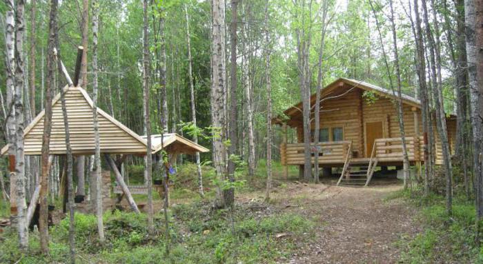
Large islands have fishing huts. They take visitors to go fishing. Arriving on Lake Piaozero, fishermen can catch a catch from burbot, giant trout, grayling and pike. In addition to fishing camps, recreation centers are actively being built on the shores and islands .
When Lake Piaozero appeared on the map
The Kumsky reservoir was created artificially in the early 60s of the twentieth century. The purpose of creation: energy supply, water supply, meeting the needs of timber rafting and the development of fishing. In the form in which the lake is represented today, it has existed since 66 years of the twentieth century. This is the result of building a dam on the Kuma River when the water level rose by about nine meters. Then several nearby villages were flooded, and their inhabitants were resettled in other villages.
Forms of a reservoir
Lake Piaozero has an irregularly shaped basin extending from the southeast to northwest. The stretches are wide and alternate with island areas. The lake has numerous small and large bays, divided by capes and peninsulas.
Piaozero refers to deep water bodies with an average depth of 15.4 meters (as mentioned above, its deepest point is 49 m). The bottom relief is complex, strongly dissected. The hollow that Lake Piaozero has is divided by a deep-water ridge going from about. Vochkola to about. Mayashuari, in the southern and northern parts. Branches of deep basins go into straits and bays. Basically, the bottom is covered with gray-green silts. In places they have a brown or buffy color. Sludge contains inclusions of ore (lacustrine).
Coastal zone
The banks of the reservoir have elevations composed of sandstones. The northern part is mostly covered with pine forest. The coastal part is characterized by frequent windbreaks (especially on prominent headlands). In these places, you can collect a bark beetle for lovers of fishing with a float, since it is impossible to dig a worm here.
The southern coast is characterized by low wetland areas of the coast. Large islands such as Vuoshkaloshuari are often visited for berry fishing. The rivers flowing into Lake Piaozero (fishing is also possible here) originate from various lakes and swamps. The main river is Sofyanga. It flows from Topozero. Another river - Olanga - flows into the northwestern part of Pyaozero. The most important are the following tributaries: p. Tawanga (west coast), Cormanga, Kela, Kitty, Zipringa (North coast) and r. Pundoma (south coast). The northern section of the lake gives rise to the river. Kume. Through it, Pyaozero water flows into the lake system of Kundozero, Sokolozero, etc., entering Kovdozero. After spending your holidays on Lake Piaozero, you will remember the local beauty for a long time.
The meaning of the name and features of the lake
In Karelia there are very interesting names of lakes and rivers. Piaozero is the main lake into which many rivers flow. The name comes from words similar to the northern dialect of the words "pyaa" - the head, and "järvi" - the lake. Water from the lake flows into the White Sea through Kovda. In Kovdozero, passing Kumu. Before Kuma, water still passes through the Kund and Sokol lakes. Up to about six meters transparent Lake Piaozero. Thanks to such transparency, fishing has a special highlight. Since November, the surface of the reservoir is covered with ice. In May, the ice melts. The nearest village to the lake is of the same name - Pyaozersky. For fishing, many fishermen prefer the northern part of the lake.
Microclimate
Together with Topozero (Karelia), Lake Pyaozero forms an integral system of reservoirs with an area of about three thousand km. sq. In the vicinity of the reservoir there is a microclimate that contributes to the deep heating of water, which makes this lake warmer than the neighboring smaller ones. In summer, the water warms up to nineteen degrees on the surface. As already mentioned, the bottom is covered with silt, and the high banks are covered with forest. The lower southern shores are marshy and covered with reeds.
The bottom with a complex relief at the depth is covered with silt, and closer to the high banks covered with forest, it becomes stony-sandy. The southern shores are lower, with wetlands and reed beds in the coastal strip. The lake has a complex configuration with numerous stretches, bays and peninsulas. The bottom relief has numerous luds and ridges. Depending on the temperature, the number of mosquitoes varies. The warmer the more. But there are fewer insects on islands than on land, even during the peak mosquito season.
How are hunting, fishing and recreation on Lake Pyaozero in Karelia?
Picturesque landscapes of Piaozero attract tourists from all over Russia and even abroad. Unfortunately, water travel cannot always be easy, as it is complicated by storms and strong winds. The territory of the reservoir was previously cross-border. Therefore, she had access restrictions. The industry did not develop near, thanks to this the ecology in the vicinity was not damaged and is in its original form: untouched nature and frightened fish ... In summer, fishing can last a whole day, due to the fact that the sun almost does not go beyond the horizon. The excellent location of Lake Piaozero offers a rich vacation and fishing. The lake is rich in fish. It happens that fishermen catch a pike weighing up to twenty kilograms, grayling up to two kilograms, trout up to ten kilograms. But there are restrictions on recreational fishing: it is required to produce young trout (trout), whitefish and grayling. In addition, a paly and whitefish require a license. Young are considered trout up to 60 cm long, whitefish - up to 26 cm, grayling - up to 20 cm. Fishing in these places is very diverse. Fish are perfectly caught on a float and spinning with trolling. Deep depressions in the basin of the lake pass close to the shore. Therefore, fishing is easy here. You can quickly catch fish from the surface. But the most interesting for fishing are trout and paly. This fish lives at a depth of more than ten meters, and the bite begins from seventeen to twenty-five meters. Palia goes closer to the bottom than trout. Trout needs larger baits.
How to get to Piaozero?
Getting to Pyaozer is not very difficult. For this, any train next to Murmansk is suitable. You can come to the Loukhi railway station, and if the trip is by car, you should go along the M-18 highway and turn left when there are Loukhi. This road leads to the village of Piaozersky. Here are gorgeous places. This is not exactly the north, but not the south. On the eastern shore there is one parking lot, which makes it possible to approach Lake Pyaozero - Umbikanda Bay (access to the water). It is not reaching Zasheyek about 10 km. You need to go to Louhi, then to Kestengi and Zasheyek for about 60-70 kilometers. In time - about three hours. For cars with low landing, there are some places with a problem moving. But you can drive ... It is advisable to have a navigator with you. On the west side, Paanajärvi National Park is located . There are often police and fish surveillance. There are parking places here. In general, there are few places for convenient parking. But a lot of stone slopes. There are popular places, well equipped, where fishermen usually come for a long time.