The Umba River flows through the northern part of Europe. Geographically located on the Kola Peninsula. The territory along which its channel passes administratively belongs to the Tersky and Kirovsky districts of the Murmansk region. The source of the river is Umbozero. In this area, the reservoir is considered the deepest (maximum indicator - 115 m). Umba flows from it from the south side. You can get to these places only by car, having left from the city of Kirovsk. Mouth - White Sea (Kandalaksha Bay).
a brief description of
The Umba River of the Murmansk Region has a length of 123 km. Located at an altitude of almost 150 m above sea level. The Umba slope is 0.83 m / km, the current is fast.
Basically, rocky mountain formations surround the river. They are covered with dense forests. Only downstream are comfortable mowing. There are many rapids on Umba, some of which are considered impassable. The shores are mostly low, but steep and steep sections are often found. The channel is winding. The bottom is mostly rocky, in the stretches of land and near the lakes - sandy, near the river. Sluggish - silty. Depth throughout the channel is changing. 2 m is considered average, and up to 4 m in reaches. The maximum depth indicator is recorded at the channel Kanozero: here it reaches 10 m. Until 1993, the Umba River was used for rafting. Previously, the channel was polluted by flooded logs. Cleaning work began only in 2009.
The width of Umba at the exit from the lake is about 150 m. Further, the river expands to 250 m. And in places where there are rapids, it narrows to 60 m. There are no cities and other industrial facilities on its coasts. Only small settlements are located here. This fact has a beneficial effect on the ecology of the river. The largest is the village of Umba.
Hydronym
About how the name of the river happened, there are two versions. The word “UMP”, or “Umb”, translated from Sami means “closed”. If we look at the place of the source of Umba, we see that the lake is surrounded by the Khibiny and Lovozero tundra. And this makes it closed on all sides. This is only one version. According to the second, the settlement of this region began from the White Sea. The first settlers did not see the river bed, and that is why it was called "closed".
Tributaries and lakes
The Umba River has 7 main tributaries. 15 km from the mouth, the river flows into the water artery. Sluggish. Its length is about 39 km. There are many rapids on it. Type of food is mostly snowy. The Inga River (the length is almost 60 km), the Kana, Muna (their length is about 40 km), Voronya and Elovaya (35 km each) and the Black (30 km) are also large.
Umba flows through 11 lakes called river channels. The total lake index reaches almost 50%. Considering that the length of the entire river is 123 km, these sections are half, and their length is about 60 km.
Seasonal Features
The Umba River replenishes its waters due to precipitation (rain) and during snowmelt. In winter, the artery freezes. Depending on weather conditions, freezing starts in late October - the first half of December. It opens closer to summer (May - early June).
Umba is a river in which the water level changes throughout the year. The lowest rates were recorded in the first months of spring (March, April). If we take the interval from September to April, then the average value of water reduction in the lower reaches will be about one meter, and in the upper sections - up to 25 cm. High water begins in May.
Umba River: Fishing
People who prefer to spend time fishing praise Umba. And it is worth noting that it is not in vain. The river is home to a lot of fish. For instance:
- predators - pike, perch;
- salmon - grayling, trout, whitefish;
- cyprinids - ide.
And these are not all representatives of the underwater world. However, visitors to fishermen need to know some points. Umba is a spawning ground for salmon. That is why fishing is necessary to obtain permission. If this is not done, then all actions will be recognized as poaching. During the spawning season, which occurs in the autumn months, fishing is prohibited.
Relaxation
Many people ask: “Why can’t you swim in the Umba River?” First of all, it is worth considering the features of the water artery: the speed of the current and the temperature regime. As mentioned above, the river is in the north. The climate here is peculiar. Summer is short and winter is long. Given that Umba is opened only in May - June, the water does not have time to warm up. It is also important that almost throughout the coast the bottom is rocky, and the flow rate is very fast. Swimming in these places is unsafe. But still, those who love cold water can stop in the reaches. There are sandy beaches and the current is not so stormy.
Umba River: Locations and Rafting
Rafting on Umba is a familiar and quite popular affair. Routes of medium difficulty. Allowed people from 16 years old. During the rafting, the lake sections mainly pass under the motor. The route is designed to bypass dangerous thresholds as much as possible. Acquaintance with the locations and instruction is carried out before the exit. Beginners are offered six-seat catamarans, which is accompanied by an instructor. Under his leadership, everyone will perfectly overcome the thresholds.
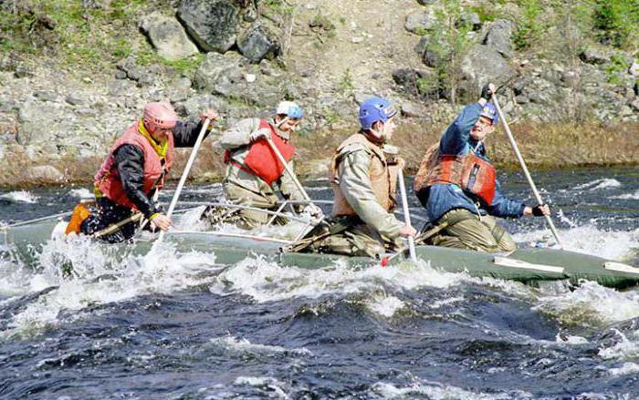
Rafting on the Umba River takes about 5 days. This is considered to be a fairly good pace, but there will not be much load. Parking, as a rule, arrange on lake sites. According to information from the locations, these are places on the Upper Cabbage Lake, Kanozero (the source of Rodving). Also, crossing the rapids Kryvets and Rogue, on the left bank you can relax in excellent parking lots. On the site "Pearl Reach" there are baths where you can steam and relax. If the weather is good, there is an opportunity to go to sea for about 15 km. Impressions from such an alloy are enough for half a life.