The mouth of the Lena River begins 150 km from the coast of the Laptev Sea, after it, bypassing Stolb Island, is divided into many channels (there are more than 150 of them). They fan out over a vast area of 45,500 km 2 , forming a classic river delta.
We begin the description of the river from the very beginning - from its source. In this case, we will take the characteristics of the parameters from officially documented information of the Water Register of the Russian Federation.
Source of the river
The small lake Nagadien, according to the State Water Register, is the source of the Lena River. It is located 7 km from Lake Baikal, on the western side of the foot of the nameless mountain of the Baikal Range with a mark of 2023 m. The source coordinates are determined by the values: north latitude 53 degrees 56 minutes, east longitude 108 degrees 5 minutes. Administratively, this is the territory of the Kachug district of the Irkutsk region. The great Siberian river begins with a small stream, which a five-year-old kid can cross. Here the channel of Lena is subject to freezing and drying out. But after the first tributaries flow into it, it acquires a constant flow.
The source and mouth of the river
Lena is located in Eastern Siberia. The river flows through the Irkutsk region and Yakutia, taking tributaries from Transbaikalia, Buryatia, Krasnoyarsk and Khabarovsk Territories.
Zero value marks the height of the mouth of the river. Lena has a length of 4294 km - such a distance is recorded in the state register of surface water bodies of Russia. The total fall is 1650 m - the difference in water level between the source (1650 m) and the mouth (0 m). The average slope is 0.38 m / km. Theoretically, this means that with each kilometer in the direction of the river’s course, the earth’s surface decreases on average by 38 cm. In fact, the channel slope and the velocity of the upper river are many times higher than the values of these hydrological characteristics at the mouth of the Lena River. These characteristics depend on the terrain.
Upper head
In different geographical conditions are the source and mouth of the river. Lena begins in the mountain system of Cisbaikalia, then crosses the Patom Highlands, goes to the Prilensky Plateau and descends into the Central Yakut Lowland. Therefore, the watercourse is conditionally divided into 3 approximately equal parts. The first of them is the upper Lena River, from the beginning to the confluence of the Vitim River. The length is 1580 km. The mark of the mouth of Vitim is 176 m, therefore, the average slope of the upper Lena is 0.93 m / km. The riverbed in the upper reaches is winding and rapids, flowing in a valley constrained by the mountains. When approaching Vitim, it becomes wide (up to 2 km) and deep (up to 12 m), sometimes the islands are divided into branches. The asymmetric river valley with a pronounced floodplain and terraces extends in breadth in places up to 30 km. The left bank is shallow - this is the Central Siberian plateau. The right bank is steep and high - the outskirts of the Patom Highlands. The slopes on both sides are covered with taiga, sometimes replaced by meadows.
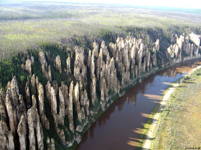
Middle course
This part of Lena with a length of 1415 km is limited by the mouths of the largest tributaries, starting from the confluence of Vitim (mark 176 m) and ending with Aldan (mark 72 m). The slope averages 0.074 m / km. Lena after Vitim becomes a full-flowing river. After flowing 2089 km from the mouth of the Olekma River, the Lena Valley narrows. The shores are rocky, they are composed of limestone. These are Lena pillars - they are sheer, have bizarre outlines. Near the town of Pokrovsk, Lena breaks out into the plain, the valley expands to 20 km or more, the floodplain covers a strip up to 15 km wide. The flow velocity slows down - from 1.5 m / s to 0.5 m / s.
Downstream
From the mouth of the Aldan to the Laptev Sea, the lower Lena extends. The length of this part of the river is 1300 km. With the confluence of powerful tributaries (Aldan and Vilyuya), Lena becomes a giant river. The width of its one-arm channel up to 20 m deep reaches 10 km, and where island formations are located, it reaches 25 km. The course of the river is magnificent - it slows down due to a slight slope of 0.05 m / km or less in the lower part of the river.
The mouth of the Lena River
A space photo shows the beauty and scope of the largest river delta in the northern hemisphere. Its area exceeds the famous mouth of the Nile by 20 thousand km 2 . The top of the delta is the island of Pillar 150 km from the sea coast. The channel of Lena is divided into one and a half hundred ducts. The largest of them are three: Olenekskaya (limits the delta from the west), Bykovskaya (eastern) and Trofimovskaya (middle), along which 70% of the annual runoff to the sea occurs. Shipping is carried out along the Bykov Channel, on which the seaport of Tiksi stands.
Since 1986, the mouth of the Lena acquired the status of the biosphere reserve of Russia - Ust-Lensky. This is a unique habitat for tundra communities represented by dozens of species of Red Book plants, mammals of 32 species. There are massive nests of waterfowl, returning here annually to continue the genus and molt. The ichthyofauna is diverse and rich.
Hydrology
The Lena catchment area is 2.49 million km 2 . The annual volume of runoff in different years ranges from 490 to 540 km 3 . The average annual discharge at gauging stations at the mouth of the Lena River ranges from 15.5 to 17.8 thousand m 3 / s.
The river is fed by atmospheric precipitation, distributed in volumes approximately equally between snow melt and rain. Groundwater recharge accounts for less than 2%, due to permafrost conditions.
The river is characterized by high spring floods, the passage of several large floods in the summer and autumn-winter low water with a decrease in the discharge of water in the lower reaches to 370 m 3 / s.
The Lena ice regime is distinguished from other rivers by a thick layer of strong ice, which forms under conditions of prolonged, low snowy and cold winters. In the upper reaches, the period without ice cover of the river lasts up to six months, in the lower reaches - a month or two less. Freeze upstream occurs in late October, and in the lower reaches at the end of September. Ice begins to break open from the upper to mid-May, and in June - at the mouth of the Lena River. In meters, the excess of the flood level over the low-water reaches values from 8 to 18, which causes flooding of the lowered territories and emergency situations in settlements along the river banks.
Unique landscapes
The pristine beauty and richness of nature, both at the source and at the mouth of the Lena River, are impressive. But the shores look especially fabulous in the Lena Pillars National Nature Park, a UNESCO World Heritage Site. Lena pillars begin 180 km from the city of Yakutsk upstream and extend for many kilometers along the right bank and in places along the left bank.
The geological and landscape phenomenon is represented by steep limestone cliffs up to 200 m high. The fantastic outlines of the pillars led the ancient man in awe, and modern tourists also admire them. Another miracle is the mountains of the cleanest and lightest fluttering sand-toukulans. At the mouth of the tributary Diring-Yuryakh, sites of primitive man were found. On the territory of the park, fossils of the ancient fauna were discovered: the remains of a mammoth, bison and rhinos.
Interesting legends can be heard from local residents about the mouth of the Lena River. An underground city with streets and eternal lamps, according to local residents, is located near the sea coast. It is only necessary to find a secret entrance into it. They also say that a German submarine molested Pillar Island at the top of the delta during World War II.