Kiya - a river in Western Siberia, a tributary of the river. Chulym. It flows through the territory of the Kemerovo and Tomsk regions. The length of the river is almost 550 km, the catchment area is 32.2 thousand square meters. km
Short description
The Kiya river (Kemerovo region) takes its beginning on the northern slope of Medvezhya (Kuznetsk Alatau), at an altitude of about 1300 m. In the upper reaches it is a typical mountain flowing through deep gorges. The lower course of the river differs from the upper, it is more quiet and flat, meandering. It flows northward and flows into the river. Chulym. The mouth is located near the village. Zyryansky. Kiya belongs to the Upper Ob basin district. The name of the water stream is associated with Turkic origin. Translated, the word “cue” means “rocky cliff”, which is quite suitable for the area where the riverbed passes . In the valley in the last century, large deposits of gold were discovered.
Neighborhood
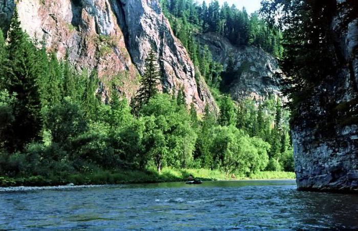
Throughout the course, the Kiya River is very picturesque. Its shores are composed of jagged rocks, the height of which reaches 20 meters. From these peaks, river water flows fall in mesmerizing waterfalls. After the confluence of the left tributary of the Kundat, the coast is represented by a deep gorge, after which the White Stone Reach begins. This site consists of stone rocks of white, light gray and brown color, in some places the height reaches about 100 m. The reach is penetrated by numerous caves and grottoes. Behind it is a nature reserve. It was created to preserve and increase the population of animals living in this region: reindeer, beaver, otter, sable and moose.
Characteristic
In the reserved area, the Kiya River has a high flow rate, a slight slope, and rifts occur. The depth of the channel in the depressions varies from 4 to 7 m. The river valley in the upper reaches is not populated.
On a site from the village. Chumai to the city of Mariinsk waterway changes character. It becomes calmer, as it flows along the flat terrain. Her channel is expanding. This section of the river is the most populated. After the city of Mariinsk, the lower course begins. This area is a dense moist taiga.
About 40 tributaries adjoin this water stream. The largest: Chet, Kundat, Shroud, Tyazhin, Antibes, Kyi Shaltyr. Also in the lower reaches of the river several elders formed: Novaya, Eldashkina, Tyryshkina, etc.
Type of food - mixed. Basically, the Kiya River is replenished by melt water. In winter, the watercourse freezes. This happens at the end of November. Kia opens in April.
Settlements
Cue flows through the territory of the Chebulinsky and Tisulsky districts. To begin your journey to the river, you need to get to the city of Mariinsk - this is the largest settlement in this area. Also on the shores of Kia there are villages: Cherdaty, Cherny Yar, Teguldet, Ust-Chebul, Ust-Sert, Dmitrievka, Shestakovo, Kurakovo, Chumai.
Tourism
The Kiya River is a popular spot for rafting. You can meet groups on inflatable boats, kayaks and even catamarans. Holidays in these places are popular, as there is very clean air and beautiful nature. By the way, it is worth noting that the Kiya is one of the few rivers of Siberia, on the banks of which there is not a single industrial enterprise. This fact has a beneficial effect on the ecological situation not only of the water artery, but also of the region in general. The air is clean, and the water is rich in fish. Often on the shore you can meet people with fishing rods. Boating fishing on the Kiya River is also possible. The predominant catch will be species such as grayling, taimen, perch, pike, roach, loach and gudgeon. In the lower reaches, spawns and sturgeons spawn.
Those who are going to come to these places to relax or go fishing need to know that the approach to the river, especially in the upper reaches, is very difficult. The roads are only country roads. After rains they are often washed away, and therefore you can get through them only on an SUV.