Most people care not about where the Adam bridge is located. Is this a real bridge or a curiosity of nature? This is what excites the minds of ufologists, occultists, and quite serious scientists. And if the dam is man-made, then the following question arises: "Who created it?". In the article we will study this problem.
Why the bridge is so called - Adam, or Rama (in Hinduism) - refers to the field of legends. When and how the passage was destroyed is established by science. Where the Adam’s bridge is located is visible on maps and images from space. Now the fate of this natural or man-made formation is being decided. Owners of marine vessels advocate deepening the passage for large ships to pass through. Environmentalists are violently protesting. After all, the 2004 tsunami was weakened on the coast of India and Sri Lanka precisely thanks to a chain of islands. The Hindus help ecologists in their struggle to protect the Rama bridge. After all, this dam serves as a confirmation of their ancient history. But let's look at the problem comprehensively.
Adam bridge: where is this attraction?
Scientific publications describe this attraction as a group of islets and shoals, which stretches in a chain from Pambana (another name Rameswaram) in the state of Tamil Nadu in southwestern India to Mannar in the north of the island republic of Sri Lanka. This formation is almost straight, only slightly bending, almost fifty kilometers. The width of the bridge ranges from one and a half to four kilometers. Between the islands, the depth of the sea is about half a meter, sometimes a little more. So, if you wish, you can go almost the whole way (more precisely, forty kilometers), wandering in the water, knee-deep, then waist-high. The only major obstacle is the Pambas Strait. It is located between Cape Ramnad and Rameswar Island. The strait is not very deep and is accessible only for the passage of small vessels. You should not test your skills and endurance and overcome Pambas by swimming. The strait is not wide, but a strong current blows such reckless daredevils into the sea.
Why is the passage between India and Sri Lanka so called?
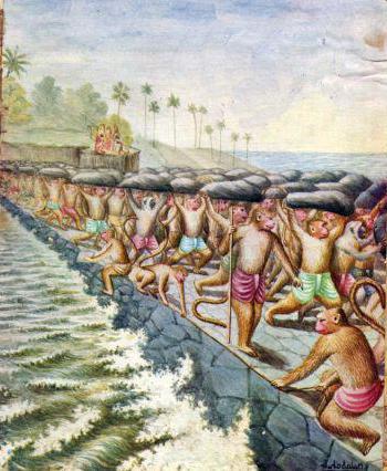
For Christian and Muslim sailors, this is the "Adam's Bridge." “Rama Bridge” - this is the name of the chain of islets and shoals of the faithful Indians. Why? Two legends explain this. Believers in the Bible believe that the story described in Genesis occurred over the island of Ceylon. God expelled Adam and Eve from his paradise, and they found themselves in no less beautiful place. The Creator of the Universe set the man in Ceylon. And so there is a mountain called Adam's Peak. God brought Eve to India. And on the bridge Adam crossed to the mainland. There, the first couple reunited and settled their entire land with their offspring. Therefore, the bridge is called Adamov. According to the Indians, the dam was built in time immemorial by an army of giant monkeys led by Hanuman. The demon Ravana kidnapped Sita, the beloved of Rama, and hid with her in Ceylon. The divine emperor ordered the construction of a bridge connecting Hindustan with the island. The work was supervised by the son of the god Vishvakarmana Nal. In this dam, the army of monkeys crossed to Ceylon and fought with the demon. All these events are described in the Hindu epic Ramayana.
What do the facts say?
On the ancient maps of the Portuguese and Arab seafarers the most real Adam bridge is depicted. Sri Lanka and the Hindustan Peninsula were connected by a pedestrian dam until the end of the fifteenth century. Even horse-drawn travelers and carts followed this bridge. But in 1480, a powerful earthquake occurred in these places. The bottom of the sea sank somewhat. And the strongest storm that began after the earthquake eroded islands and spits that went under water. Unfortunately, this was not the last blow of the elements. In 1964, a powerful cyclone completely destroyed the city of Dhanushkodi, which was located on a sand spit eighteen kilometers southeast of Rameshvarama. Only the temple of Kothandaraswamy survived. According to the Ramayana, in this place Rama captured some of his enemies. And not far from the bottom of the sea is another temple, on the date of construction of which there is no information. From Kothandaraswamy officially begins the Rama Bridge.
Tourist attraction
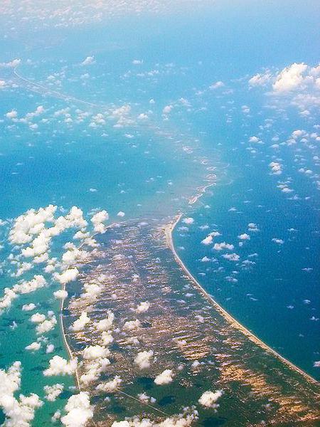
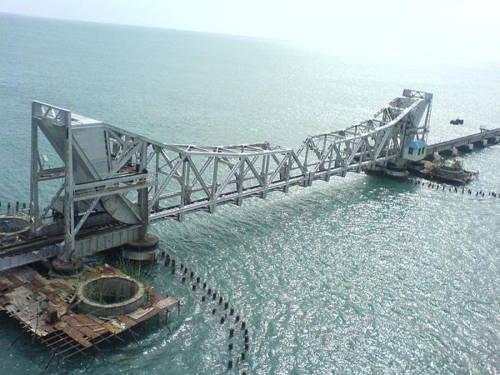
Near the islands are nothing special. They are composed of petrified corals, pressed sand and igneous rocks. This enabled scientists to argue that the Rama bridge is just the remains of a reef, like many atolls in the tropical and equatorial latitudes of the ocean. It is much more interesting to contemplate this attraction from the air, from the porthole of an airplane, for example. Adam’s bridge, the photo shows this very clearly, looks like man-made. The shallows are clearly visible, and it seems that the dam extends over the water continuously. Due to the latitude of a couple of kilometers, the Rama bridge is visible even from space. And pictures taken by NASA several years ago shed light on the origin of the strange mound. The Indian Geological Survey descended to the study of the Rama bridge. Its specialists drilled a number of wells and took rock samples. In addition, transport links are possible in some places between the mainland and the islands. A railway bridge has been built across Pamban Bay . It connects mainland India with the island of the same name.
Who built the Adam bridge?
Alas, this question is still open. Although more and more people are inclined to think that this dam is of artificial origin. But is it man-made? After all, the age of this building (if we have the right to call it that) is quite solid. Some give the dam several million years! What kind of civilization could have built a bridge when Homo Sapiens was not yet a biological species? Can we assume that the bridge was built by aliens? But if some highly organized community could cover so many kilometers calculated in light years to reach the Earth, does it not seem strange that to overcome fifty kilometers it needed to build a dam from boulders? It is more reasonable to consider that the bridge is about three to five thousand years old and its builders are representatives of the Neolithic civilization?
Arguments for Natural Origin
Adam's bridge is a chain of islets. Perhaps, and even most likely, the island of Ceylon (now Sri Lanka) in ancient times was part of Eurasia. Millions of years ago, under the influence of the movement of geological plates, the formation of the strait began. The bottom sank (as happened already during the earthquake of 1480) and only the islands remained on the site of the former isthmus. In the warm tropical sea, coral reefs grew around them, and the course caused sand. From this, long braids formed, which people used until the end of the fifteenth century to get to Ceylon.
Arguments for Artificial Origin
Aerial shots show how blue the sea is around the Rama bridge. The depth there is significant - about ten to fifteen meters. If we assume that the Adam bridge is the remainder of the isthmus, it is not clear where the rest of the mainland shelf went. This ridge appears at a depth quite unexpectedly and, thus, represents a clear natural anomaly. Yes, sounding showed that the bridge is made of sand and corals. But in fact among the building material there are boulders, as well as in places and limestone. In addition, studies have revealed a clear form of masonry. The boulders are clearly shaped two and a half meters and a half. These stones are laid on top of a layer of sand - and this is the most obvious evidence of the artificial origin of the embankment.
NASA Conclusions
Pictures of this authoritative American space exploration agency shed more light on the mystery of the bridge than the comments of its experts. The photo was taken from an orbiting satellite at maximum expansion. Looking at the picture, it is impossible to assume that all this is a curiosity of nature. But the conclusion of NASA experts leaves the question open: "The image of this object obtained by remote sensing from orbit cannot provide specific information about its age and origin." So the Adam bridge remains a mystery of our time.
The struggle for the preservation of attractions
It doesn’t matter if this embankment is man-made or natural, but it impedes navigation. Ships must make a four hundred-kilometer detour to reach Ceylon from the southern part of Hindustan. As early as the nineteenth century, the British raised the question of expanding the Pambas Strait for passage of large vessels. In the fifties, even the government of D.Neru decided to liquidate the Adam bridge. But a giant storm destroyed all the technical undertakings of the work. The salvation of the Rama bridge is now advocated not only by the brahmanas, who claim that it is proof of everything described in the Ramayana. For the safety of the chain of islands and environmentalists advocate. After all, this mound, they believe, mitigates the effects of tsunamis and large storms on two coasts.