Hearing the word Kiribati, many probably just shrug their shoulders. Relatively little is known about this state, which is not included in the list of popular tourist destinations.
Where is Kiribati located? This tiny island country on the map can be found in the western part of the great Pacific Ocean. The land area of the Republic of Kiribati consists of 33 atolls. So called coral islands, having a ring-shaped shape. Small coral islands are also part of this state. In the waters of the Pacific Ocean, all these small patches of land are spread over an area exceeding 3.5 million square kilometers.
The country includes island groups. These are the islands of Gilbert, Phoenix, and also Line. The last of them in their location on the world map relate to the southern part of the Hawaiian Islands.
Geographic location
The Republic of Kiribati is located in Polynesia and Micronesia. In the northwest, it borders the territorial waters of two states, namely the Federated States of Micronesia and the Marshall Islands. In the south-west and west, Kiribati has maritime borders with Tuvalu, the Solomon Islands and Nauru.
In the southeast and south - with waters belonging to Tokelau, the Cook Islands, as well as French Polynesia. In the northeast and north, the republic borders on the Outer Small Islands, which are part of the United States, as well as Pacific neutral waters. The coastal strip of Kiribati has a length of 1143 km.
Geography
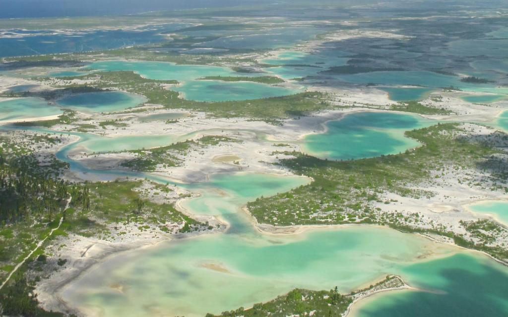
As mentioned above, the Republic of Kiribati is located on the atolls, one of which, Banaba, is elevated. According to the theory put forward by Charles Darwin, the formation of such formations was facilitated by the immersion of volcanic islands and the gradual fouling of their surface with corals. This process led to the emergence of first bordering, and after barrier reefs. Thus, land appeared in this part of the Pacific Ocean.
The total area of the atolls of the Republic of Kiribati is 726.34 square kilometers. The distance from the easternmost to the westernmost island of the state is 4 thousand kilometers. All atolls are divided into 4 groups. They include:
- 16 islands of the Gilbert archipelago;
- 8 islands that are part of the Phoenix archipelago;
- 8 islands included in the Line archipelago;
- Banaba island, which is also called Ocean.
Gilbert Atolls are located in the southeast of Micronesia. Their area is about 279 square kilometers. All atolls of the archipelago are conditionally divided into three groups, in each of which a different amount of precipitation is noted. This includes the North, Central, and South Islands. In this archipelago on the territory of the Tarawa Atoll is the capital of Kiribati - South Tarawa.
East of Gilbert, 1480 km from it, are the Phoenix Islands. This archipelago includes 9 uninhabited islands and one inhabited (Canton), which is located in Polynesia.
Further east on the map you can find Central Polynesian Sporades. This is the Line archipelago. On its territory is the island of Christmas (aka Kiritimati), which is the largest atoll on our planet. Located in this archipelago is the easternmost section of Kiribati. This is Caroline Island.
All islands of the Line archipelago, besides Terain, Tabuaeran and Kirimati, are uninhabited. Of the 9 atolls of the Phoenix, people live only in Canton.
Each of the small land plots that make up Kiribati is divided by a large number of narrow straits and has a shape somewhat elongated from south to north. Almost all of the atolls of Kiribati have small salted lagoons. They are surrounded by land, either in full or in part.
The highest point of the country is a nameless area. It is located on the island of Banaba and has a mark of 81 m.
Climate
Most of the atolls of the Gilbert archipelago, as well as a small part of the group of Phoenix and Line islands, are located in the dry belt of the oceanic equatorial zone.
The main feature of the climate of Kiribati is its uniformity. In this island state, the air temperature does not fall below +22 degrees. In different parts of the country, its range is +28 ... + 32.
For a long time, the local inhabitants of Kiribati distinguish two seasons throughout the year. One of them begins in October and lasts until March, and the second lasts from April to September. The first one is more rainy.
From December to May, winds prevail in the country of Kiribati that blow northeast and east. From April to November, air flows enter the territory of the atolls from the east and from the southeast. And from December to May, the winds are stronger.
The climate in Kiribati is dependent on the inter-tropical convergence zone, which determines the level of precipitation on the atolls located in the northern part of the country, as well as the South Pacific, on which the level of precipitation in the south depends. These sections, on which the air flows converge, are directly connected with the El Niño currents, as well as with La Niña. In the first of these, the convergence zone moves north to the equator, and in the second, it moves south from it. With the latter, the islands of Kiribati are prone to severe drought. In the first case, significant rainfall occurs in their territory.
The driest months of the year are May and June. The rainy season in the Republic begins in October and lasts until April.
Nature
The soil on the islands of Kiribati due to their coral origin is very poor and highly alkaline. Most of them are porous and poorly retain moisture. There are very few mineral and organic substances in the soils of the country of Kiribati. The only exceptions are magnesium, sodium and calcium.
Phosphate soils are common throughout the republic. There are brown-red soils on the islands formed from guano, which is a decomposed litter of seabirds, as well as bats.
Interestingly, it is impossible to see the river on any of the atolls of Kiribati. The absence of water bodies on the islands is explained by their small area, low altitude, and also soil porosity. The only source of fresh water on the atolls is the so-called lenses formed by rainwater that has seeped through the soil. You can get to the moisture by digging a well. Such lenses on most atolls in Kiribati are the only source of fresh water. After rains, locals also extract moisture from the leaves of coconut palms.
Freshwater lakes can be found only on two islands of the state. This is the atoll of Christmas and Theraine (Washington). In total, there are about one hundred small salt lakes in the land area of the Republic of Kiribati. Some of them reach a diameter of several kilometers.
The relatively young geological age of the atolls, their remoteness from the continent, as well as adverse weather conditions contributed to the fact that only 83 species of local plants in Kiribati. And not one of them is endemic. In addition, it is believed that several plant species were introduced into these territories by natives. Among them are:
- such a peristadone;
- breadfruit of two types;
- yam;
- giant tarot;
- tarot;
- swampy giant taro.
Plants such as coconut palm and pandanus roofing are likely to be of dual origin. On some atolls they were introduced by man, and on others they are indigenous representatives of the flora.
Four species of plants, namely pandanus, breadfruit, coconut palm and taro, played in the old days and continue to play a leading role today in the nutrition of the inhabitants of this island country.
The main representatives of marine fauna are pearl mussel, holothurians (sea cucumbers), cones, tridacs, palm thieves and lobsters. In the ocean near the islands there are a lot of fish, of which there are from 600 to 800 species. The coastal waters of Kiribati and corals are rich.
As for fish, it has always been the main food for local residents. In coastal waters reef perch, albul, khanos, large-headed mullet, sultanok and horse mackerel are caught. Several species of sea turtles are found near the islands.
The animal world of the atolls is rather poor. During the American scientific expedition in the early 19th century. the researchers found here only the only representative of terrestrial mammals - the Polynesian rat. Today, island residents raise pigs and poultry.
But the world of avifauna in Kiribati is very diverse. The country has 75 species of birds, one of which is endemic. This is a reed bird. She lives on Christmas Island.
On most land areas of the Phoenix and Line archipelagos there are large-scale bird markets. That is why the islands of Starbuck and Malden, as well as part of the Christmas Atoll, are declared the zone of marine reserves.
History
Little is known about how the islands of Kiribati were populated. There is an assumption that the ancestors of modern local residents moved to the atolls of Gilbert in the 1st millennium A.D. from eastern Melanesia. But the Phoenix and Line archipelagos remained uninhabited by the time they were discovered by the Americans and Europeans. Nevertheless, traces of the presence of a person who lived here in the distant past can be found on these atolls. A similar fact allowed scientists to assume that the local population for some reason left these archipelagos. One of the most popular versions explains this by its small land areas, remoteness from other islands, an arid climate, and a constant shortage of fresh water. In connection with all these factors, living on these atolls was difficult. Most likely, the people who settled the islands soon left them.
The discoverers of archipelagos located in the western part of the Pacific Ocean are American and British expeditions. Their ships visited these places from the end of the 17th century. to the beginning of the 19th century Atolls were originally called the Gilbert Islands. It happened in 1820. The name was given to the islands by a Russian traveler and Admiral Kruzenshtern in honor of the British captain T. Gilberg, who discovered these lands in 1788. By the way, “Kiribati” is a local pronunciation of English gilberts.
The first settlers from Britain arrived on the islands in 1837. In 1892, these territories became a protectorate of England. Christmas Island joined the colony in 1919, and the Phoenix became part of it in 1937.
During the Second World War, Japanese troops came to these territories. They occupied most of the Gilbert Archipelago and Banaba Island. One of the most bloody battles in the Pacific took place on the atoll of Tarawa. Here in November 1943, battles were fought between the American and Japanese army.
In 1963, the colonial authorities carried out the first significant reforms on the islands, leading to the formation of the Consultative and Executive Councils. The first of them included representatives of the local population, appointed by the resident commissioner operating in these territories. In 1967, the Executive Council was transformed into the Government. And the Advisory delegated its authority to the House of Representatives. The latter included officials of the colonial administration, as well as 24 members elected by the indigenous population. In 1975, the territories of the archipelago were divided into two independent colonies. One of them included the Ellis Islands, and the other - Gilbert. In 1978, the first of them achieved independence and became a separate state. Its modern name is Tuvalu.
07/12/1979 gilbert islands became independent. Today we know them as the Republic of Kiribati. The territories of this state were enlarged in 1983. This happened after the entry into force of the friendship treaty between Kiribati and the United States. According to this document, America abandoned its claims to 14 islands located in the Phoenix and Line archipelagos, recognizing that they are part of the Republic.
The main problem of this state has always consisted and consists in the overpopulation of the atolls belonging to it. In 1988, part of the inhabitants of Tarawa were resettled to other islands with fewer people.
In 1994, the country elected its president. They became Teburro Tito. We re-elected him in 1998.
In 1999, the republic became a member of the UN. In 2002, a law was passed in the island nation of Kiribati that allowed the government to decide to close newspapers. This happened after the appearance of the opposition publication.
In 2003, President Tito was re-elected. However, in March of that year, he was removed from his post. In July 2003, Anote Tong, who led the opposition party, became the head of the country. Today, the post of head of state is held by Taneti Maamau.
An interesting, but at the same time, a sad fact in the history of Kiribati: in the 20th century. the atolls of Kiritimati and Malden USA used to test their atomic weapons. In 1957, England detonated a hydrogen bomb off the coast of Christmas Island.
Economy
The development of the national economy of the state of Kiribati was proceeding at a rather slow pace. The exception is only the period from 1994 to 1998. At this time, the country was experiencing rapid economic growth thanks to measures taken by the government.
But in 1999, GNP growth was only 1.7%. The combination of a slow economic growth rate and a low level of services led to the fact that out of all 12 Pacific countries included in the Asian Development Bank, Kiribati was in 8th place. A comparison was made when calculating the human development index.
The formation of this small country is hindered not only by the fact that it owns only a small part of the land. A negative role in the development of the economy is played by geographic and environmental factors, including significant remoteness from the main markets for goods, the great distance of the islands from each other, restrictions on domestic sales and vulnerability to natural disasters.
How is the development of the economy of the state of Kiribati possible? This will happen only if:
- attracting labor migrants with the offer of citizenship of Kiribati;
- cash assistance from other countries;
- state financing of the national economy.
However, with such a development model, it is necessary to maintain a high level of domestic consumption.
Until 1979, that is, until independence, the country exported phosphates. Their deposits were actively developed on the island of Banaba. Export of this mineral reached 85% of the total volume of products sold abroad, and the money earned for it amounted to 50% of the state budget and 45% of GNP. In 1979, the deposits were fully developed. Since then, the country began exporting fish products and copra (dried pulp of coconut fruit). Another source of income for Kiribati is the issuance of licenses for fishing in its waters.
The main employer in this island republic is the state. However, it is not able to solve the problems of youth employment, which for the most part does not have the necessary education.
An additional source of income for Kiribati in recent years has been the issuance of licenses for fishing rights in the special economic zone.
Population
Judging by the data available as of July 2011, 101 998 people lived in the republic. 33.9% of the population of Kiribati were children under 14 years old. The largest group of local residents, whose age ranged from 15 to 64 years, included 62.4%. People over 65 years old are residents of the islands, the number of which reached 3.7% of the total. The average age of state citizens is 22.5 years. According to 2004 data, population growth was 1.228%.
The inhabitants of the Gilbert Islands are Kiribati and Malaysians. All of them speak a language belonging to the East Austronesian group. It is called "Kiribeti." In the atolls of the Line and Phoenix archipelagos, most of the local residents are the Polynesian Tuvalu. The official languages here are English and Kiribati.
Belief
What religion is dominant in Kiribati? 52% of believers adhere to the teachings of the Roman Catholic Church. Congregational Protestants in the Islands 40%. The remaining inhabitants of the country are Muslims and Seventh-day Adventists, Mormons and Baha'is, followers of the Church of God, etc.
Coat of arms
This state symbol of the country was approved in 1979 after the island state gained independence. The coat of arms of Kiribati is an image of a yellow frigate bird that flies over the blue-white waves (symbol of the Pacific Ocean) and over the sun. . . «, » .
. . , , .
Money
For payments in the Republic of Kiribati, the Australian dollar is used. But besides him, since 1979, the country has its own banknotes. These are Kiribat dollars. Their ratio to the Australian is 1: 1.
Available in Kiribati and coins. Their face value is 1 and 2, 5 and 10, 20 and 50 cents. In the form of coins, 1 and 2 dollars are used in Kiribati.
All metal money is made in the same sizes as the Australian ones. The exception is only a coin in denominations of 50 cents, as well as 1 dollar. Interestingly, the first of these coins is round, and the second is in the shape of a dodecagon.
Time
The Pacific state is located immediately in 3 time zones. So, on the atolls of the Line archipelago, time in Kiribati is ahead of Moscow by 11 hours. On the Phoenix Islands, by ten hours. On the Gilbert Atolls - for 9 hours
One of the interesting facts about Kiribati relates to the passage through the countries of the “date line”. The Phoenix and Line archipelagos lie east of it, already in the western hemisphere. However, they are conditionally considered to be located in the east. This avoids a temporary paradox when it is still Sunday in one part of the country and Monday is on the islands of the other.
On 01.01.1995, the Government of Kiribati decided to consider that the country is in the same time zone. Nevertheless, based on the vast extent of its territory, in practice this is not at all observed. Most often, the time on the islands is indicated exactly as it is based on its time zone.
Capital
The bulk of the population of the republic lives on the Gilbert Islands. Moreover, most of them are located on the atoll of Tarava. Here is the capital of Kiribati - the city of South Tarava. About 50 thousand inhabitants are registered in it. In addition to the capital, the city of Kiribati - this is another 9 settlements, the number of which exceeds 1.5 thousand people.
The residential areas of the capital of Kiribati (photo can be seen below) are located on several small islands, interconnected by bridges and dams.
South Tarava has four municipalities. Their names are Betio and Bairiki, Bikinibeu and Bonriqui. All these municipalities are located on the islands of the same name, being part of the capital of the state of Kiribati. It is in their territories that all the main commercial, government and educational institutions of the country are located. So, in Betio there is a power station operating for the entire atoll, the Maritime Institute and the port. Interestingly, this island is almost flat and devoid of vegetation. All its central part is occupied by a wide strip of Hawkins airfield. It is in this place that the sights of Kiribati are located, which are military relics of the period when the famous battle for Tarawa took place. Among the monuments reminiscent of the fierce battle on Tarawa are the Memorial Chapel built in the village of Abaroko, as well as the Memorial to the Heroes of the Outpost, which commemorates the 22 English servants killed by the Japanese in October 1942.
The most important feature of Betio are military cemeteries, which can impress anyone with its many rows consisting of wooden tombstones, because on the island, whose length is only 3 km, more than 5.5 thousand victims of the war are buried.
The president lives in Bairiki and the parliament sits. Here is the city market and the National Court of Kiribati, as well as some ministries. Bonriki is considered the tourist center of South Tarawa. This is where the largest hotel, designed for 60 residents, the Ministry of Education and the National Hospital is located. Bikibibeu has an airport.
Boils life on the small islands that make up Tarava. So, on Eita is a high school. Moroni has a small fish market and a church, Amvone has a nine-golf golf club, Teaorerek has Saint-Louis College and Catholic headquarters. A supermarket and a Tarava-Motors car dealership were built on the islet of Antebuk. Tiny reefs in the northern part of the capital of Kiribati attract the attention of tourists. It is here that a large number of pile houses are located that are rented to travelers for living.
On the many islands is the only Main Street. It goes on land, then through passages in the reef, then along the bridges.
The capital of Kiribati (photo below) is located only three meters above sea level. In this regard, any natural disasters can have a devastating effect on all objects of the atoll. In addition, the island does not stop the process of soil salting. This negatively affects the supply of fresh water, which is clearly not enough here.
Many locals earn their living by collecting coconuts and catching pearls.
South Tarava is located in the equatorial climate zone. Year round, the capital of Kiribati is warm and rather humid due to the high average rainfall. Air temperature averages 25-30 degrees above zero.
Interesting Facts
The Republic of Kiribati is the only state in the world that is located simultaneously in all hemispheres - in the East and in the West, in the South and in the North.
As part of the country is the largest atoll on our planet (388.39 sq. Km). This is the island of Christmas, occupying 48% of the land of the republic.
At Caroline Atoll, located in the Line archipelago, people are the first to celebrate the New Year (outside of Eurasia and Antarctica). This is due to the fact that this island is the most eastern part of the land, located in the zone of the 12th time zone.
Since January 28, 2008, the Phoenix island group is the largest marine reserve on the planet. Its area is 410.5 thousand square meters. km