A hiking trail does not overgrow to the Lovozersky tundra (Russia, Murmansk region) . But this region is also developed by mining enterprises. After all, the mountain ranges on which the tundra are located are composed of valuable, sometimes unique minerals. These are nepheline syenites, rare earth metals, tantalum, niobium, cesium, cerium, eudialyte. But the mining industry does not interfere with tourism. You will find routes along the virgin mountain tundra. The severe northern nature and inaccessibility of these places gave rise to a large number of legends. We saw UFOs and snowmen here, and the local population believes that a mysterious city of shamans is hiding under a ridge. Hiking in these places is very popular, despite the vagaries of the weather. River rafting is also famous. In this article we will talk about the Lovozersky tundra, their nature, relief. We also provide information on popular tourist routes.
Location
The Kola Peninsula on the map of Russia is located in the far northwest. Ter, Kola, Murman - in the old days these harsh places of the Arctic were called. They are inhabited by Sami or, otherwise, Lapps. Now the indigenous people of the Kola Peninsula is an ethnic minority. But all geographical names still have Sami names. So, the tundra of interest to us are called Luyavrurt. Some confuse them with the Khibiny. But these mountains are located several tens of kilometers to the west and are a completely different ridge in composition. Luyavrurt or, as the tundra is also called, Lovozerye, stretched in the shape of a horseshoe. If we look at the Kola Peninsula on the map, then the tundra are in its west, but east of the Khibiny. The area of Lovozero is almost a thousand square kilometers. This is the second highest ridge after the Khibin. The highest point of the mountain range is Angvundaschorr. It is only sixty meters below Lyavochorra, the main peak of the Khibiny (1189 m above sea level).
Climate
Most of the Kola Peninsula lies north of the Arctic Circle. Therefore, one cannot count on special heat. But winters are not as severe as you might expect by looking at the map. Indeed, in the extreme northwest of Russia, the warm breath of the Gulf Stream is felt. On the coast of the Kola Peninsula, the temperature in January averages eight degrees with a minus mark. But since the tundra is a rather high mountain range, altitudinal zoning must also be taken into account. Very strong piercing winds blow here, and snow can fall even in July. Speaking of summer. It's pretty cool here - the same eight degrees, only with a plus mark. High air humidity and piercing wind contribute to the fact that a person feels this temperature as close to zero. Going on a hike, you need to take very warm clothes.
Relief
Luyavrurt is the oldest mountain range on our planet. And by the variety of useful minerals, he knows no analogues. In the west, Luyavrurt is bounded by Umbozero. The eastern border of the ridge is another reservoir. It is called Lovozero. Due to the relatively mild climate formed by the Gulf Stream, this area lies in the natural zone of the taiga. Coniferous forests approach the mountain range from the north and south. But in view of the altitudinal zonation, the slopes of the ridge are occupied by the tundra. These mountains have an average height of eight hundred and fifty meters. Their characteristic feature is the absence of pronounced peaks. The mountains are rather flat tops, but the slopes are steep, steep. The ridge reaches its greatest height in the west. The peak of Angwundaschorrd is located there. The eastern part of the massif is occupied by low hills up to four hundred meters.
Nature
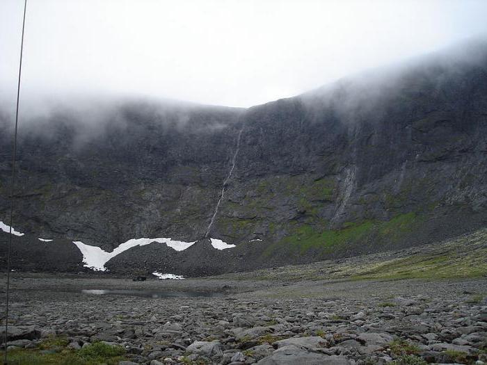
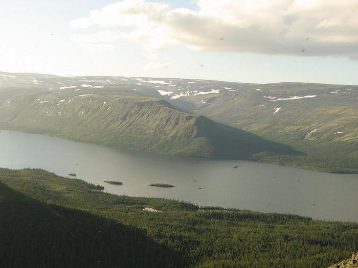
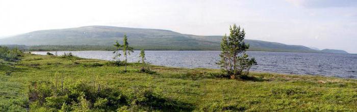
Lovozerye is a bizarre mystical combination of blue lakes, waterfalls, ringing streams and rocky cliffs. Rock screes sometimes have such regular outlines that it seems as if it is a pavement laid out by ancient Hyperboreans. Along the shores of ice lakes, snow lies year-round. And also Lovozerye, these are riding bogs covered with moss soft as feather-beds, and, of course, the mountain tundra. At the foot of the mountains there are birch forests and berry bushes, where in the summer there are a lot of blueberries, blueberries, cloudberries, lingonberries, and in the autumn - mushrooms. Everyone who has visited the Lovozero tundra will tell you that the main representatives of the local fauna are midges. But they will cease to haunt you with height. In the center of the Lovozero tundra lies the mystical Seidozero. It, together with the adjacent slopes and gorges of the mountains, is included in the Seydyavr nature reserve. In the protected nature reserve, you can find many species of birds.
Equipment
Due to the steep slopes and extremely bad roads, only hiking is possible in this region. But on the Lovozersky tundra laid numerous routes, some of them include elements of rafting. A typical hike lasts from four days to a week. All routes are of medium difficulty. The peculiarity of the ridge is such that first you need to overcome steep rocky slopes. Then the path runs through a fairly flat area. Therefore, it is necessary with responsibility to approach the choice of shoes for hiking. Preference should be given to strong trekking boots on grooved soles. During the hike, they often wade across mountain streams. To do this, you will have to bring along “coral slippers” (slippers and flip flops without fastening on your feet can be carried away by the current). It is imperative to have a strong raincoat in the campaign, which will not tear the strong wind to pieces. And finally, a sleeping bag. It should be designed for low temperatures. Trekking poles are welcome on the hike (they can be borrowed by skiing). And bring warm clothes with you!
Lovozero tundra: routes
Hiking starts from different settlements of the Kola Peninsula: Apatity, Krasnoshchelya, Revda, Olenegorsk ... But most routes necessarily go to Seydozer. This pond is located in the very center of the “horseshoe” of the Lovozero tundra. Tourists and two circuses of Raslak do not ignore. These geological formations are almost perfect round bowls with a diameter of several kilometers. An ancient glacier dug steep walls of circuses up to two hundred and fifty meters high. Some routes include the conquest of the main peak, as well as the Alluive Mountains. This is one of the few "thousandths" in the Lovozero massif. The Geologists Pass will connect Alluive with Angwundascorrd. So you don’t need to go down to climb up later. Seydozero is the pearl of all, without exception, routes along the tundra of Luyavrurt. Many people specially come to the Kola Peninsula to see this pond. Its banks are full of various "religious buildings" of the ancient Sami. And fans of the cosmic hypothesis are sure that seydi, guria and other formations are the work of unearthly civilization. At the end of the trip, tourists can visit the Sami History Museum.
Ghost towns
The Lovozero tundra is also interesting because abandoned settlements are often found on the tourists' path. Once the region was the center of the mining industry. Geologists, builders, plant workers, lumberjacks settled in the mountain tundra and on the mountain slopes. Now the area is completely “at the mercy” of tourism. But the ghost settlements remained. The last inhabited village is Revda. It is located north of Alluive Mountain, a few kilometers away. Tourists departing from Revda pass Ilmu. This ghost village was abandoned in the forties. Still further is the once-located village of Alluive. It was founded in 1937 and amicably left by residents in the fortieth.
Krasnoshchelye
This is the third most populated village of the Lovozero tundra. Six hundred five people live there. Krasnoshchelye interesting because in this village people live in a patriarchal economy. There is a deer farm here. Sami also survive through fishing, picking mushrooms and berries. There are no year-round roads connecting Krasnoshchelye with other settlements. The usual message is by air. People come here to look at the patriarchal life of the Sami, and then go to the Lovozero tundra.
Typical route. The first day
As mentioned above, trips to the mountain tundras of Luyavrurt last from four to seven days. At the same time, the group is not very large - about ten people. There are routes in which inflatable boats are involved in the movement. But the channels between the lakes are often swampy; you have to drag the shuttles by dragging knee-deep in the water. There are few cheerful rifts, as in the Khibiny, in the Lovozero tundra. A typical route starts from Olenegorsk, the nearest railway station in Luyavrurta. From this town a minibus takes the group to the village of Revda. From it begins exclusively the walking part of the route to the Lovozero tundra. The campaign starts in the morning of the next day. And on the first day, tourists are invited to see the Stone Museum in Revda. Local artisans make various souvenirs from scattered everywhere rare minerals. Sometimes it is possible to drive an SUV to an abandoned mine on the slope of Mount Karnasurta. This place is interesting because there were discovered three unique minerals that are not found anywhere else on the planet - laplandite, lovdarite and dawns. Tourists advance nine kilometers along the Ilmayok channel. Passing the pass of Voronny Gora (Karnasurta), they descend to the Elmorajok stream and camp for the night.
The second and third day of the campaign
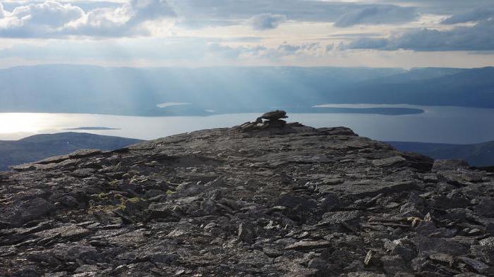
Some routes provide radial (circular) walks light around the camp. Numerous mountain trails lead up from the Elmorejok Creek. Without much baggage, tourists climb along the course of the Tulbnyunuay stream to the peak of Kedykvarpahk (one thousand one hundred eighteen meters above sea level). From this mountain, the name of which translates as "Rockfall", a beautiful panorama opens up over the entire ridge. In the absence of cloudiness even Khibiny are visible. The road along the stream is very picturesque. The Tulbnyunuay stream broke through a soft canyon in a deep canyon with high and steep walls. Cascades and waterfalls will accompany tourists all the way. In the taiga at the foot of the mountains there are many thickets of blueberries, crowberries and lingonberries. On the third day, tourists are removed from the camp and reach the key place of the campaign - Seydozer. On the banks of this vast reservoir there are many convenient parking lots. But it is best to camp at the confluence of the Kukluhtnunui creek on the north side of the lake. There is a sandy beach and, if you're lucky with the weather, you can swim. On the south side are the peaks of Chivruailatv and Ninchurg.
Seydozero
All routes devote at least a day to this pearl of Luyavrurt. A path has been laid along the entire shore of the lake. Sometimes there are buttocks. Since the Lovozero tundra are protected places, a forester lives here. His hut is the only building for many kilometers of wild and deserted terrain. What you need to know about Seydozer? There are legends about this pond. Some of them are quite modern. So, it is believed that the circuses of Raslak are take-off sites for UFOs. But scientists found that he created these two round "bowls" of the glacier. On the coastal cliff of Seydozer you can still distinguish the Kuyva figure. Although it was proved that this bas-relief was created by nature and consists of stones covered with moss and lichens, folk rumor endows it with miraculous power. However, under the influence of erosion Kuyva gradually collapses and loses its “human appearance”. Now, in order to see an old man with a beard in a rock, you need to really strain your imagination. Legends claim that in the bowels of Mount Ninchurg, on the southern shore of the lake, a secret city of shamans is hidden. Modern studies have not confirmed the presence of caves in the array. But the travelers still continue to call the lake Shamansky and consider it a “place of Sami power”.
The fifth and sixth days of the campaign
Leaving the relatively comfortable shores of Seydozero, tourists begin to conquer the mountain range. A dirt road rises steeply along the turbulent river Kukluhtnunuay. There are cascades along the way, beautiful pearl waterfalls. First, the road leads through the forest, winding between fir and spruce. Then thickets of dwarf birch begin and, finally, a group of tourists rises to the mountain tundra zone. This is the flat top of Mount Kuyvchorr (the name is connected with the same character of Kuyvor). From above opens an incomparable view of the blue Seydozero lying as if in a palm. Walking on flat peaks is quite easy, but you need good sturdy shoes, because you have to step over piles of stones. The local mountains are composed of sedimentary rocks. Therefore, in the midst of stone chaos, no, no, and even there are flat plates, as if carved by a human hand. This gave rise to the myth that there was once a civilization of Hyperboreans in the Lovozero tundra, which paved the way. After a fifteen-kilometer march, tourists stop for the night on the banks of the Svetlaya River. The next day, the group descends along its stream abounding in waterfalls. Crossing the river ford (the width of the stream at this place is ten meters, and the depth, if there was no rain - thirty centimeters), tourists get on the path leading to Lake Svetloye. On its shore, at the foot of Wavnbed, the group that covered nine kilometers that day is spending the night. The proximity of civilization is felt on the lake. At the very least, cell phones catch the signal.
Last day of the campaign
A week has passed, which means it's time to leave the Lovozero tundra. The end of the route usually looks like this. The group from the Pond Light goes to Lovozero. The path crosses the tourists river Sergevan. Since there is no ford here, it will be necessary to overcome the water barrier through a suspension bridge. Then you need to get to the village of Lovozero. But to get to the village, you must first go around the swamp with terrible swamps. The transition from Svetly to the village of Lovozero is twelve kilometers. We described a typical seven-day itinerary. But there are also shorter ways. The rather wide and deep Motka River flows into Seydozero. The upper course of the water artery is located near the village of Lovozero. Therefore, it is possible to transfer tourists by boat. In Lovozero there is a Museum of Sami history. It is recommended to visit it to complement the impressions gained during the trip. There are also grocery stores in Lovozero where you can buy groceries by train. In this village, a minibus is already waiting for tourists to take them to the train station in Olenegorsk. There are alternative hiking start points. For example, in the western part of the ridge, from the village of Vakhtovoye. To explore the southern, highest peaks of the Lovozersky tundra, you should go up from the Seydozer trail along the Chivruai valley.