The Ho Chi Minh Trail is one of Vietnam's largest attractions, which attracts tourists from all over the world. The trail is a complex of land and waterways with a length of more than 20,000 km, which stretched across the lands of Cambodia and Laos, and during the Vietnam War they were used to transport weapons, ammunition, fuel to the territory of South Vietnam. It is believed that the trail was crucial for the triumph of North Vietnam. By the way, this name has American roots, and the Vietnamese themselves called this area the "Cheongshon Path," by the name of a mountain range nearby.
Those who appreciate military history would be happy to personally see the extensive network of narrow, semi-overgrown paths and narrow roads covered with gravel that stretch along the Lao-Vietnamese border. The cunning interweaving of mountain and forest paths that connected North and South Vietnam, Cambodia and Laos during the military confrontation has survived to the present.
Who is Ho Chi Minh
First President of the Democratic Republic of Vietnam, ideologist and founder of the National Liberation Front of South Vietnam. It was this communist organization, led by Ho Chi Minh, that launched an uprising against the country's president and laid the foundation for a long and bloody war.
History of occurrence
In 1957, a guerrilla war broke out on the territory of South Vietnam , which was raised by the rebels against the elected president Ngo Dinh Diem. Almost 2 years after the start of the armed clashes, the North Vietnamese authorities decided to support the rebels. For this, an armed transport detachment was assembled, which was faced with the task of organizing an uninterrupted supply of military equipment to South Vietnam. The first transport corridor was laid along the demilitarized zone between the North and the South, but was soon discovered and destroyed. The new route, which later received the name “Ho Chi Minh Trail”, circled the demilitarized region and entered the land of Laos.
At that time, a civil war was raging in Laos. The border areas were controlled by the communists from the Pathet Lao movement, who sympathized with the rebels of South Vietnam and did not impede the passage of vehicles through their lands. Cambodia officially declared neutrality, but the government, represented by Prince Sihanouk, granted broad powers to the North Vietnamese army and allowed its territory to be used.
Development
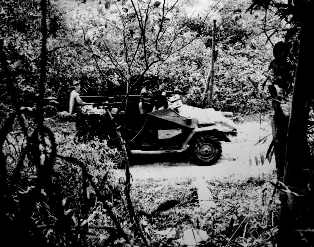
During the war, the Ho Chi Minh trail continuously expanded and as a result turned into an extensive network of several large roads and narrow trails running parallel to each other. Transshipment stations were built along the entire length, where soldiers of transport detachments were resting. Most of the way passed through forests and jungles, so it remained completely invisible from the air. All objects were carefully masked, the road was covered by an air defense system, which included large-caliber anti-aircraft machine guns.
In addition to moving weapons, ammunition, fuel and other military equipment along the trail, detachments of North Korean soldiers regularly moved. As a rule, they traveled all the way on foot, although the length of the Ho Chi Minh trail was more than 2000 km. At first, foot porters and elephants were used to transport goods, but soon trucks replaced them.
After the departure of the American military, the trail was converted and improved. In 1975, it turned into a wide all-weather road with a width of almost 8 meters. An oil pipeline with a length of about 2,000 km and a telecommunication line were also built here.
Attempts by the Americans to destroy the trail
The mountainous landscape prevails in the northern regions of South Vietnam , so there weren’t so many convenient exit points for the overpass. At these points, major battles were constantly taking place. Cambodia and Laos formally remained neutral, so US troops could not cross their borders and destroy the Ho Chi Minh trail. A special detachment was created for covert operations in the neutral zone, which was engaged in reconnaissance, placement of motion sensors, sabotage activities and the capture of prisoners.
In 1964, the US military received permission to conduct military operations in Laos. The trail was regularly bombed; they tried to erode it using climate weapons. The army of North Vietnam suffered enormous losses, but the Americans failed to completely block this artery.
The significance of the trail for victory in war
Both Americans and Vietnamese agree with the fact that the Ho Chi Minh trail was crucial for the victory of North Vietnam. Researchers confirm that since 1968, the military power of South Vietnamese rebels has rested solely on supplies from the northern part of the state. The regular army of the North waged all the main battles. Both military equipment and soldiers arrived in the southern regions directly along the trail. If the opposing side managed to cut this corridor, the outcome of the war could be completely different.
Where is the Ho Chi Minh Trail
The main and original path is in Vietnam. It runs along the Vietnamese-Lao border.
However, the path of the same name exists near St. Petersburg. This path appeared in 1960 and stretched from the granite quarry in Kuznechnoye to Lake Hawk itself. Of course, in this region on the border with Karelia there has never been a war, therefore, from the point of view of history, there are no attractions on the trail. But tourists can enjoy the beautiful views, go fishing and mountain climbing.