Today we will talk about the land of Wrangel. This island is very interesting. He was unsuccessfully searched for by a Russian traveler, and the British and German discovered it. Then the deserted island became the "bone of contention" between the Soviet Union and the United States of America. This land is surrounded by legends. There is even an opinion that one of the colonies of the ominous Gulag was located here. But even without repressive camps, this land was murderous for humans. Not one polar explorer died here. And today the island continues to amaze scientists with new sensational discoveries. How the island was formed, what is the relief, climate, animal and plant life - read in this article.
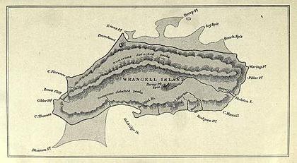
Wrangel Island on the map
This is a fairly large plot of land. Its area is approximately seven and a half thousand square kilometers, and most of it is occupied by mountains. The island itself is located in the Arctic Ocean. Even in the simple geographical location of the land of Wrangel, its uniqueness is already hidden. It is a watershed between two large ocean areas, a natural border between the Chukchi and East Siberian seas. And also on the island of Wrangel runs a junction between the Eastern and Western hemispheres of our planet. The one hundred and eightieth meridian, the so-called “date line,” divides the land into almost equal parts. The island is separated from the northern coast of Chukotka by at least 140 kilometers of water - Long Strait. Since 1976, this land has been declared a reserve. The last permanent resident died in 2003. Since then, only polar scientists have been living here. Administratively, the island belongs to the Chukotka Autonomous Okrug (Iultinsky District).
Discovery story
We can say with confidence that the Wrangel land was the first to be discovered by the Paleo-Eskimos. As archaeological excavations carried out in a ravine called Devil prove, people stopped here at the camps three and a half thousand years ago. The Russian pioneers were told about the existence of the distant land of Umkilir (the "island of polar bears") of the Chukchi. But two hundred years passed before the foot of a European stepped on a deserted and unflattering shore. For a long time, the island was considered only a beautiful Chukchi legend. In 1820-1824, he was unsuccessfully sought by the Russian navigator and statesman Ferdinand Petrovich Wrangel. In 1849, a British explorer and traveler, Henry Kellett, observed two pieces of land in the Chukchi Sea through a telescope. The discoverer named them after himself and his ship Herald. Thus appeared “Kelletta Land” and the island of Herald (later Wrangel Island) on the world map. But this is not all the adventures of our part of the land surrounded by the sea.
Why the discovery was named after Wrangel
The island was considered unknown to Europeans (the opinion of the Chukchi about Umkilir was not taken into account). The discoverer’s right belonged to one who not only saw the distant shore with a telescope, but stepped on it with his foot. It was a German merchant, Eduard Dallmann, who conducted merchant operations with residents of Chukotka and Alaska. But he was far from the idea of somehow calling the lands he visited. A year later, in 1867, Thomas Long landed on an island from America. By calling, this brave man was a researcher, knew a lot about the searches of F.P. Wrangel. Therefore, he named the island he discovered in his honor. The territory was a draw for about 14 years. In 1881, an American ship approached the islands of Harold and Wrangel. It was looking for members of the polar expedition of De Long, who went to conquer the North Pole in 1879 on the ship "Jeanette" and was missing. Captain Calvin Hooper landed part of the team on the island. While the sailors were looking for signs of the missing, the captain hoisted the US flag on the shore. He called the island New Colombia.
Archipelago formation
Until the twentieth century, the governments of Russia and the United States were little interested in who owned two pieces of land lost in the Arctic Ocean. Such an attitude was promoted by their “distant” geographical coordinates. Wrangel Island, for example, is the most western in a small archipelago, located between 70 ° and 71 ° north latitude. The length along the meridian at this place is simply unique: from 179 ° C. d. to 177 ° c. The archipelago is very close not only to North America, but also to Asia. This is all that remains of the once existing bridge between the two continents, when the Bering Strait has not yet separated them. Thus, these are islands of mainland origin. And therefore they are also called Beringia. This area was spared by the ice ages, and during global warming the islands did not go under water. This circumstance has preserved on the land of Wrangel an amazing fauna and flora.
The polar apple of discord
With the onset of the twentieth century, and at the same time the century of industry, both applicants claimed their rights to the archipelago. It doesn’t matter where the Wrangel Island is located, whether someone lives there and whether it is possible to conduct business. The borders of adjacent states are shifted east or west, respectively, if someone takes possession of the archipelago. In the fall of 1911, a Russian hydrographic expedition aboard the Vaigach vessel landed on Wrangel Island and raised the Russian flag on it. And in the summer of 1913, the Canadian brigantine “Karluk” was sandwiched by ice and was forced to drift towards the Bering Strait. Part of the team landed on the island of Herald, and the other - a large party - on Wrangel. Two members of this expedition reached the mainland (Alaska), but the rescue expedition came to those in distress only in September 1914.
Mastering the archipelago
In 1921, Canadians decided to "stake out" the archipelago in the Chukchi Sea. After all, this gave the state the possibility of fishing and whaling near their shores. But the first settlers, consisting of four polar explorers and one Eskimo woman, did not survive the winter (only Ada Blackjack survived). Then the Canadians in 1923 formed a second colony. The geologist C. Wells and twelve Eskimos came to Wrangel Island, among them women and children. Since professional hunters were engaged in food production, the colonists successfully survived the winter. But the Soviet government sent the Red October icebreaker equipped with guns to the shores of the island. His team forcibly lifted the settlers aboard and took them to Vladivostok, from where they later extradited them to their homeland. As a result of such a trip, two children died.
Wrangel Island is ours!
How did he finally become “domestic”? Although the Wrangel Islands appeared on the map of Russia, the government did not calm down until the Russian colonists established themselves there. In 1926, the polar station was founded, which was led by researcher G. Ya. Ushakov. Along with him settled another 59 Chukchi from the villages of Chaplino and Providence. In 1928, the Ukrainian journalist Nikolai Trublaini came there on the Litke icebreaker. He repeatedly described in his books (in particular, “The Way to the Arctic through the Tropics”) the Wrangel island and its severe beauty. Collective farms were to be everywhere in the Land of Soviets, and the Far North was no exception. In 1948, a reindeer collective farm was founded - for this purpose a small herd was brought from the mainland. And in the 70s they introduced musk oxen from the island of Nunivak. Although evil tongues claim that one of the Gulag camps was based on the archipelago, this is not true. The villages of Ushakovskoye, Perkatkun, Zvezdny and the village. Cape Schmidt was inhabited either by polar explorers or by Chukchi tribes.
Reserve land
Back in 1953, the authorities decided to protect walruses and their rookeries on two islands in the Chukchi Sea. Seven years later, by its resolution, the Oblast Executive Committee of Magadan created a wildlife sanctuary on Wrangel Island. Later (1968) he was promoted. But the Soviet government did not stop there. The reserve of national importance in 1976 was transformed into the nature reserve "Wrangel Islands." The zone is still protected according to the decree of the Council of Ministers of the RSFSR under No. 189 of March 23, 1976. The plural in the name of the reserve is not a typo. The neighboring island of Herald, as well as about 1,430,000 hectares of water, was also protected. Ironically, the conservation of nature was greatly facilitated by the crisis of the late 1990s. Most of the residents were taken to the mainland, because there was no means to supply them with fuel and food. The last inhabitant of Vasilina Alpown was bitten by a polar bear in 2003. And in 2004, both islands were included in the UNESCO World Heritage List.
Relief
A map of Wrangel Island shows that this land area is quite mountainous. Three almost parallel chains - the Northern, Middle and Southern ranges - break off the coastal cliffs. The highest point - Mount Sovetskaya - reaches 1096 meters above sea level. It is located almost in the center of the island. The low Northern Range passes into a swampy plain called the Academy Tundra. The lowlands of the island are dissected by lagoons. There are a lot of lakes and rivers. But there is no fish in them. Due to the harsh climate, these ponds freeze through in the winter. However, global warming is noticeable here. In recent years, schools of pink salmon began to actively spawn at the mouth of rivers. The rugged topography and polar location created a number of glaciers on the island.
Climate of Wrangel Island
The polar night here comes in the second decade of November, and the long-awaited sun appears at the end of January. The star does not go beyond the horizon from mid-May to the third decade of July. But even the fact that the sun constantly illuminates the Wrangel Island does not add heat to the local summer. The temperature even in July does not exceed +3 ° C. Snowfalls, drizzle and fog are frequent. Only in the abnormally hot summer of 2007 did the thermometer jump to +14.8 ° C (in August). Winters are very frosty, with frequent snowstorms. Especially February and March. The temperature during this period for many weeks does not rise above the –30 ° C mark. Cold air masses from the Arctic carry little moisture with them. But in the summer, moist winds blow from the North Pacific.
Flora
B.N. Gorodkov, who studied the vegetation on the east coast of Wrangel in 1938, mistakenly attributed the island to the zone of Arctic deserts. Further study of the flora prompted scientists to the idea that its territory lies in the belt of the polar tundra. And to be very precise, the classification is as follows: Wrangel sub-province of the West American Arctic tundra zone. Flora is distinguished by its ancient species composition. Three percent of the plants are subendemic. This is Gorodkov’s poppy, bezkilnitsa, Wrangel ostracodus and others. At present, it has been revealed that by the number of endemic species, Wrangel Island has no equal in the polar zone. In addition to these plants, which are found only here and nowhere else in the world, more than a hundred rare species grow in the reserve.
Fauna
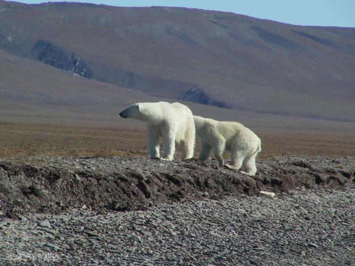
Severe climatic conditions do not favor particular species diversity. There are absolutely no amphibian, reptile and freshwater fish on the island. But the Wrangel Island, whose photo is unlikely when without a white bear in the foreground, is the champion in the density of these animals. Judge for yourselves: on an area of about seven and a half thousand square kilometers four hundred damsels coexist. And that's not counting males and cubs! So the Chukchi name of the island is justified - Umkilir. Moreover, the population of this beast is increasing from year to year. The polar bear is the main owner of the island. In addition to it there are introduced reindeer and musk ox. In the summer, the wind blows bumblebees, butterflies, mosquitoes and flies from the mainland. The world of birds has about 40 species on the island. Of rodents, Vinogradov's lemmings are endemic. In addition to bears, there are other predators: polar fox, wolf, fox, wolverine, ermine. The local walrus rookery is the largest in Russia.
Unique discovery
In the mid-1990s, the Wrangel Island Nature Reserve was on the front pages of scientific journals. And all because paleontologists discovered the remains of mammoths here. But what was important was not the find itself, but its age. It turned out that on the island, these elephants overgrown with thick hair lived and lived another three and a half thousand years ago. But it is known that mammoths became extinct over ten thousand years ago. What turns out? When in Greece was the heyday of the Crito-Mycenaean civilization, and Pharaoh Tutankhamun reigned in Egypt , a lively mammoth walked around Wrangel Island! True, the local subspecies also differed in small growth - the size of a modern African elephant.