The urban-type settlement Kamskoye Ustye is the administrative center of the Kamsko-Ustinsky district (Republic of Tatarstan).
Description of the area
This district center is located on the right bank of the Volga River opposite the place where the Kama flows into it, 117 km south-west of the city of Kazan. Currently, there are 53 settlements on its territory, including three urban-type villages (Tenishevo, Kuibyshevsky Zaton and Kamskoye Ustye), and 21 municipalities. The relief is an elevated plain, its height is 170-190 m above sea level. It is divided by ravines and gullies, as well as a steep ledge that breaks off to the edge of the Volga River. The area is rich in reserves of gypsum, clay and dolomites. The following water arteries flow on its territory: Volga (Kuibyshev reservoir), Ishimka, Karamalka, Sukhaya Ulema and its tributaries, Mordovian. Soils here are mainly gray, forest dark gray and light gray, sod-carbonate and brown-gray. The forest cover of the region is 8.7 percent.
Population
According to the 2010 census, 16.4 thousand people live in the district. Of these, the urban population is almost eight thousand, and the rural population is 8.4 thousand. The average population density is 14 people per square kilometer. National composition: 54.7% are Tatars, 42.3% are Russians and 3% are representatives of other nationalities.
Industry
In the village of Kamskoye Ustye (Tatarstan) and its district there are six industrial enterprises. The largest are the gypsum mine (founded in 1911), the creamery and the Kuybyshev Fleet Repair Base (transferred here from Spassky Zaton in 1954).
Agriculture
The main production potential of the district center of Kamskoye Ustye is agriculture. The largest agro-industrial structure occupies more than ninety percent of agricultural land. In addition, there are 128 small farms. The basis of livestock breeding is dairy and beef cattle breeding, the main cultivated crops are rye, barley, wheat and peas.
Transport
Due to the location of the village at the confluence of the Kama and Volga rivers and away from the railways, the main modes of transport are road and water. Moreover, river arteries entered the transport network of federal significance, and roads - only of local importance. This is the highway Kazan - Kamskoye Ustye, roads to Apostolovo, Tetyushi and Upper Uslon. In addition, oil pipelines were laid in the territory of this region.
The medicine
Medical care in the village of Kamskoye Ustye is provided by the central hospital. In addition, there are 35 feldsher-midwife centers and three medical outpatient clinics in the district. Due to the fact that only three pharmacies operate in the entire region, according to the agreement with the main pharmacy, the sale of medicines is carried out in feldsher points.
Tourism
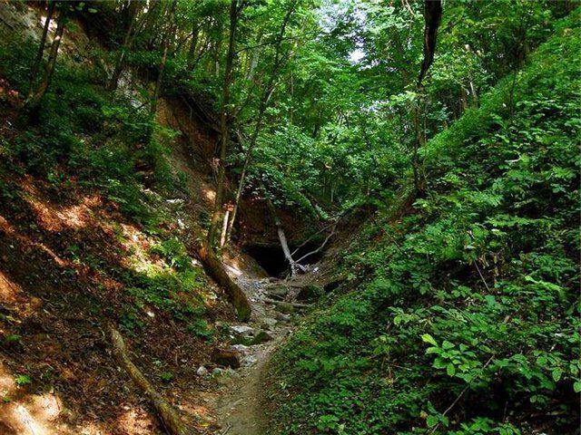
The Kama Estuary annually attracts flows of tourists and fishing enthusiasts. Vacationers are given the opportunity to visit a number of protected natural sites. Such as Lake Baikul (Karamalskoe) and Forest Lake, the Tenkovskaya feather grass steppe (plants growing here are listed in the Red Book of Tatarstan), as well as the nature reserves Antonovskie ravines, Labyshinskiy mountains (in this natural complex , very rare animal breeds were found for this area) and Mount Lobach. In addition, caves in the Kama Estuary are very popular: Konnodolskaya, Zimovieva, Bogorodskaya and Yuryevskaya. The territory of this village revealed the most valuable archaeological sites that date back to the Upper Paleolithic. For guests and residents of the area in the Kama Ustye sports complex “Akcharlak” works.
Fishing
Kama Estuary is famous for ecologically clean places, fantastically beautiful nature, favorable conditions for fishing - all this attracts lovers of such a rest from all nearby and not so cities. Here, between the Zaton of Kuibyshev and the village of Kamskoye Ustye, there is a fishing and hunting base "Kama open spaces". It works year-round; here they provide fishermen with a full range of services, from housing and meals to delivery to fishing areas. For lovers of winter fishing, there is another base - “Cool place”. A diverse bottom topography, good depths, and, most importantly, the presence of various fish species speak in favor of choosing this area. In the summer period, zander, bream, bream, bersh, scavenger, burbot, catfish and many other species of both simple and predatory fish are well caught. In winter, the catch can be made by bersh and pike perch, and sometimes burbot, which falls on the hook either in the early morning or late evening.
Among experienced fishermen, several places for ice fishing are especially popular. These are the Kama Estuary, Supper Dol, Zimovye, Rodnik and Old Pier (near Mount Lobach), the Armenian Beach and Stone Buoy. Of course, this is not a complete list of the favorite places for winter fishing by the local residents, however, even for their development you are unlikely to have enough time allotted for the vacation.
Kama Estuary: caves of the region
One of the most popular among tourists is St. George's Cave, which is widely known in the republic and beyond. It is located near the village of Tenishevo. It was first investigated in 1953 by A. V. Stupishin. The size of the Yuryev cave was less than two hundred meters. However, in May 1971, newcomers to the Kazan speleo section during her visit managed to disassemble a pile of stones, as a result of which they penetrated into its new part, the length of which was more than 360 meters. In 1986, St. George's Cave was declared a natural monument of regional importance. In 2008-2009, cavers from Naberezhnye Chelny re-shot famous parts of this stone structure. It turned out that the size of the cave reaches 507 meters. However, they did not stop there, and in 2010, as a result of excavations, another large tunnel was discovered. Today Yuryevskaya cave is the longest of the natural formations of the Middle Volga. Its length is 990 meters. And in 2011 it has already reached 1005 meters, and the area is 3500 square meters. m. The entrance to the cave is at the bottom of the ravine. It is divided into three different tunnels. The first of them leads to the "Grotto of Rains", the second is called "Flounder" or "Skuroderka", and the last - "Triangle".
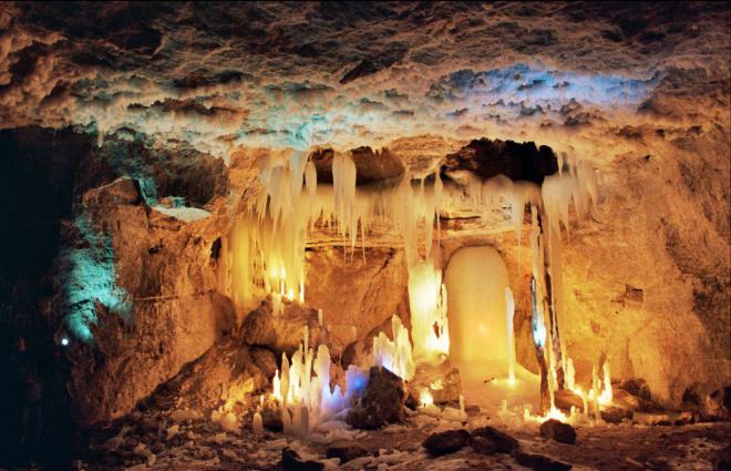
In order to get into the last of them, you should go through the abyss three meters deep, leaning on the ledges on the sides of the walls. If you manage to overcome it, then the look will reveal the indescribable beauty of the
wondrous grotto. The second move is a very narrow hole, you can squeeze through it only with your hands forward, and even then at a certain angle. Immediately I recall a cartoon about Winnie the Pooh and his trip to the Rabbit. Only those who have a muffled instinct for self-preservation will be able to crawl through this “skin”. However, immediately after it a new surprise awaits you - a two-meter cliff. If you survived, move carefully along the wall, clinging to various ledges. Of course, getting here is not easy. But it's worth it. And finally - "Grotto of the rains." It got its name due to the fact that water drips from its ceiling. The result is an illusion that it is raining. So if you like outdoor activities and want extreme sports and adventures, then the Kama Estuary with its caves is what you need.