Franz Josef Land, whose islands (and a total of 192) have a total area of 16,134 square meters. km, located in the Arctic Ocean. The main part of the territory of the Arctic part of the Primorsky district of the Arkhangelsk Region. Geographically, it is divided into 3 large parts: eastern, central and western. The first includes the islands of Wilcek Land (2 thousand square kilometers) and Graham Bell (1.7 thousand square kilometers). They are separated from the rest by the Strait of Austria. The largest group of islands is located in the central part. It is washed by the British Channel and the Strait of Austria. The western region includes the largest island of the alliance - George Land with an area of 2.9 thousand square meters. km Franz Josef Land for the most part has a flat, plateau-like surface. Its average height reaches 400-490 m, and the highest point is 620 m.
Detection
The existence of a group of islands east of Spitsbergen was predicted by more than one great Russian scientist: first Lomonosov, and then Schilling and Kropotkin. Moreover, the latter in 1871 submitted his plan of expedition to the Russian Geographical Society for their study, but the government refused to allocate funds. The Franz Josef Land Archipelago was discovered only by chance. This happened when the Austro-Hungarian expedition led by J. Payer and C. Weiprecht set off in 1872 to develop the Northeast Passage. However, their ship turned out to be sandwiched by ice, and gradually it was west of Novaya Zemlya. In 1873, on August 30, the schooner "Admiral Tegetgoff" moored to the shores of unknown land. At the same time, Payer and Weiprecht examined its northern and southern outskirts. Prior to this, where Franz Josef Land is located was not known to anyone. In April 1874, Payer managed to reach a point with a coordinate of 82 ° 5 'north latitude. He also made a preliminary diagram of the archipelago found. At that time, it seemed to researchers that it consisted of a number of large sections. The open land received the name of the famous Franz Joseph I, the Austrian emperor.
Mastering
In 1873, Payer and Weiprecht explored the southern part of the territory, and in the spring of 1874 they crossed it across from south to north on sledges. At the same time, the Land of Franz Joseph was first schematically depicted. The map, as it turned out later, had many errors. In 1881-1882 the open territory on the yacht "Eyra" was visited by the Scot B.L. Smith. And in 1895-1897. English geographer Frederick Jackson conducted many important surveys of the southwestern, middle, and southern parts of the alliance. Subsequently, it turned out that the group consists of a much larger number of islands than anticipated. However, they were less significant in comparison with the symbols on the map of Payer.
Around the same time period, the northeastern and middle parts of the archipelago were visited by Nansen and Johansen. In June 1896, the Norwegian Nansen accidentally discovered on about. Northbrook Wintering Frederick Jackson. In the summer of 1901, Vice-Admiral S.O. Makarov visited and visited the southwestern and southern shores of the islands and conducted their survey. In the course of the work, the approximate size of the entire territory was established. Then in 1901-1902. research works continued to be conducted by American scientists Baldwin and Ziegler. Following them from 1903 to 1905. A new expedition was organized to reach the pole on the ice. It was led by Ziegler and Vial. In the period from 1913 to 1914, a group of geographers G. Ya. Sedov conducted work in the Bay of Tikhaya near the island of Hooker. In the summer of 1914, the last surviving members of the Brusilov expedition - Albanov and Konrad - managed to reach the old Jackson-Harmsworth base. It was located on Cape Flora about. Northbrook. There, geographers were rescued by the visiting schooner St. Fock.
Accession to Russia and further development
In 1914, an expedition led by Islyamov visited the island in search of a group of G. Ya. Sedov Island. He declared the area part of the territory of Russia and raised the flag. In 1929, in the Bay of Tikhaya Fr. Hooker Soviet scientists opened the first research station. Thanks to her, Franz Josef Land has since begun to host annually Soviet polar expeditions. In the 50s. Twentieth century were reorganized units of the air defense forces of air defense. One of them took Franz Josef Land. The military base was on about. Graham Bell. The 30th separate radar company and a separate air commandant's office are located here. The latter served the ice airfield. But these are not all the strategic objects that the Franz Josef Land possessed. Alexandra Island hosted the 31st separate Nugarskaya radar company. These units belonged to the northernmost military units of the Soviet Union. In the early 90's. they were eliminated. In 2008, in the course of research on a nuclear icebreaker called Yamal, it detached itself from Fr. Northbrook is a piece of sushi. In honor of the Arctic captain, she was named after Yuri Kuchiev. On September 10, 2012, the expedition of the AARI on the atomic icebreaker "Russia" discovered another detached part from about. Northbrook.
Population
There are no municipalities and permanent residents on Franz Josef Land. The temporary composition of the population includes the FSB border guards, employees of research stations. Periodically, military personnel of the air defense unit also live here. They carry out missile defense of the northern direction of Russia. According to press reports, in 2005 the most extreme post office "Arkhangelsk 163100" was opened on the territory of the island of Hayes. The time of his work should have been only 1 hour, from 10 to 11 hours from Tuesday to Friday. According to data from September 2013, the post office "Arkhangelsk" (Hays Island, Franz Josef Land) is listed under the postcode 163100. His work schedule is from 10 to 11 hours every Wednesday.
Glaciers
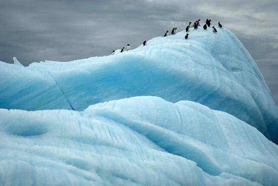
They cover most of the surface of the archipelago (87%). Thickness varies from 100 to 500 m. Icebergs subsequently form from glaciers descending into the sea. The eastern and southeastern parts of the entire territory are more susceptible to icing. New formations appear only at the very tops of ice sheets. Moreover, according to the results of the research, the cover of Franz Josef Land is very rapidly declining. If the observed rate of its destruction remains the same, glaciation of the territory after 300 years may disappear forever.
Franz Josef Land. Hot, cold?
A typical Arctic climate extends to a group of islands. The average annual temperature on about. Rudolph reaches -12 ° C. In July, in the Tikhaya Bay of Hooker Island, the air warms up to -1.2 ° C, and on the island of Hayes, where it is located. Krenkel (the northernmost meteorological station in the world), - up to + 1.6 ° C. The average temperature in January is about -24 ° C, and the lowest reaches -52 ° C. Maximum gusts of wind - 40 m / s. In the zone of accumulation of ice sheets, an average of 250 to 550 mm of precipitation falls annually.
Arctic Flora and Fauna
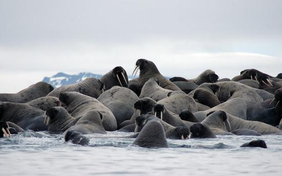
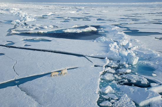
Mosses and lichens predominate in the vegetation cover of the archipelago. Grains, polar willow, saxifrage, and polar poppy are also found. Among mammals, you can see a polar bear. Less often comes across a white fox. Walrus, harp seal, beluga whale, narwhal, sea hare and seal live in coastal waters. The birds are richer in the fauna of the archipelago - there are only 26 species of winged ones. Among them there are chistiki, ordinary warrior, guillemots, white gull, luriks, burgomaster, etc. In summer they form bird markets.
Trips to the North Pole
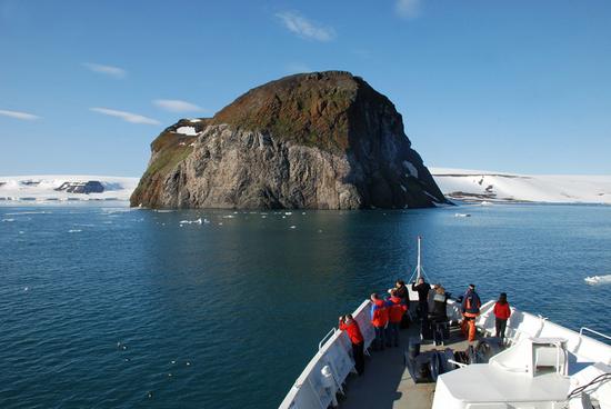
How much does a cruise to the Franz Josef Land archipelago cost? Tours to the Arctic can be purchased at a cost of 875 076 rubles. ($ 24,995). Yes, a very expensive pleasure! The trip may include a trip with an expedition team to the Franz Josef Land Wildlife Sanctuary. Undoubtedly, this is one of the most unusual and luxury vacation options. The excursion program offers its guests to reach the “Top of the World” - 90 degrees c. w. aboard the world's most powerful nuclear icebreaker, 50 Years of Victory. The conquest of the ice expanses ends with a polar barbecue on the ice cover, a fun round-the-world round dance and swimming in the Arctic Ocean. On the way back, travelers will be offered helicopter tours to the islands of the archipelago, an incredible panorama of which will surely captivate with its beauty. 540 miles to the North Pole is the habitat of a huge number of seals, arctic birds, walruses and polar bears. In the case of planning such a tourist trip, one should take into account the fact that the trip takes place in an inaccessible, poorly studied and remote part of the globe. As a result, the route of the program can only be considered as a general, familiarization plan of the expedition, because under the influence of external factors such as ice conditions, weather, etc. it can change. As a ten-year practice shows, not a single expeditionary trip to the Arctic repeats exactly the previous one. The nature of the North Pole makes its adjustments. This is the peculiarity and specificity of expeditionary cruises.
General travel plan
Day 1
Arrival in the city of Murmansk, landing on an icebreaker. At the pier, waiting for a group of travelers to board, there is the most powerful nuclear-powered icebreaker in the world with the lyric name “50 Years of Victory”. After some time, the ship will leave the mainland and set off to meet new experiences, passing by the Kola Bay.
Day 2
In the Barents Sea. An integral part of each expedition is the preparation of passengers for the features of an unusual journey. Members of the organizational team will acquaint vacationers with safety rules on board the ship and helicopter, as well as talk about all the nuances associated with the implementation of landings in the Arctic.
Day 3-5
Direct course to the Arctic. Three subsequent busy days spent on the ship will introduce passengers to interesting historical facts and the amazing nature of this region.
Day 6
Arrival at the North Pole. On approaching the destination, the captain will lead the icebreaker to the coveted coordinate, 90 ° north latitude, with slow, clear maneuvers. After the ship stops, vacationers will go down to a suitable ice floe and conduct the already-traditional rite of "round-the-world procession". Then follows another interesting ritual - travelers will be asked to write notes, which are subsequently placed in metal capsules and immersed in the abyss of the Arctic Ocean.
Day 7-9
Destination - Franz Josef Land. Despite the fact that the main task of the expedition has already been completed, travelers will still expect many interesting, impressive events. Well-preserved buildings allow you to track the most important historical events that took place on the archipelago many years ago. Among them, it is worth noting the house on about. Bell, built in 1881 by members of the Lee Smith expedition, and the ruins of an old camp on Fr. Northbrook. It was there that in 1896 a significant meeting took place between Nansen and Jackson. It is also worth a visit to Cape Norway, where Nansen F. and Johansen conducted joint research for a long 7 months; to honor the memory of the scientist G. Ya. Sedov, whose image became the prototype of the protagonist when creating the novel "Two Captains" by Kaverin. The pristine expanses of the Arctic and the peculiarity of the landscape gives its guests the Franz Josef Land. Photos taken in this area are always striking in their uniqueness and beauty. Glaciers resembling moon craters, combined with multi-colored moss carpets and vibrant poppy flowers create an amazing, indescribable atmosphere of harmony. An obligatory component of the Arctic landscape are also thousands of bird markets and walrus rookeries that fill the coastal horizon of the Franz Josef Land archipelago. A photo in the bosom of polar nature will allow you to capture a unique moment in life and keep it in memory for many years.
Day 10-11
In the Barents Sea. It's time to return to Murmansk. On the way back, the captain will invite travelers to dinner in his apartment. There, passengers can relax in an interesting company and listen to entertaining real stories about service on the icebreaker from the original source.
What is included in the total cost of the tour
- Travel aboard the icebreaker "50 Years of Victory."
- Scheduled group excursions. They include all shore trips, visits to places of historical significance and other activities by helicopter.
- Excursions on the zodiacs (by decision of the expedition leader due to worsening weather conditions can be canceled).
- Lecture program prepared by well-known naturalists and specialists of the region.
- Four meals a day (including fresh pastries for an afternoon snack); coffee and light snacks throughout the day; drinking water.
- Rubber boots for rent during the cruise.
- Information materials for acquaintance and expedition diary with photos on DVD.
- Postage and technical costs.
- Special jacket for the expedition.
- Medical accident insurance on board.