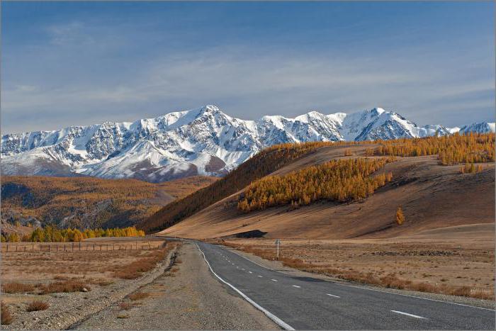
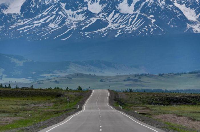
The M-52 road (formerly P-256) is the main transport artery of Altai. It runs along the route Novosibirsk - Biysk - Tashanta. The length of the highway is 953 kilometers. The picturesque section from Biysk to Tashanta was called the Chuysky tract. Most of the way passes through the Altai Republic. Annually Chuysky tract attracts the attention of a huge number of tourists from different parts of the world. And he is one of the five most beautiful roads in the world. Today we will consider the history and main attractions of the Chuysky tract (Altai).
Historical reference
Before considering the sights along the Chuysky tract, we will get acquainted with the history of the construction of this road. In the Chinese chronicle of a millennium ago, there are mentions of a road called the Mungal tract, which is located exactly on the site of the modern Chui tract. Probably, this road was one of the branches of the Great Silk Road, along which trade caravans followed to Mongolia. Thus, a tourist who visited the Chuysky tract can not only enjoy the beauty of the surrounding landscapes, but also touch the centuries-old history.
In 1756, when the southern Altai volunteered to join the Russian Empire, the development of the tract began. In Russian-language sources, the first mention of it dates back to 1788, when merchants reached the Chuya River. Rapidly developing trade relations entailed the expansion of the path. Nevertheless, until the beginning of the twentieth century, the tract was considered a dangerous mountain trail, movement along which was accompanied by serious risk.
Since the 1860s, when the government became interested in strengthening political and economic ties with Central Asia and the Far East, projects to build a solid road began to be considered. However, none of the proposed ideas has been implemented. It is assumed that there were two reasons for this: the lack of a technical base and the government’s reckoning on financial assistance from the merchants. Entrepreneurs gradually adapted the road to more comfortable and safe movement on it. So, by the beginning of the 1890s, it was possible to move relatively safely along the section from Kosh-Agach to Khabarovka: the path was expanded, stones were removed, stone barriers and wooden floorings over the steeps were installed.
In 1901, large-scale construction of the Chuysky tract nevertheless began. Two years later, the site was ready from Kosh-Agach to Ongudai. Then the local population and peasants from the nearest settlements were involved in the work. About one and a half hundred people participated in the construction. Due to lack of funds and the desire to maximize the cost of work, the constructed road was quickly destroyed. Over the next ten years, it was not repaired and by the beginning of the 1920s was again in a deplorable state.
In 1911, the Chuysky tract was assigned to the Ministry of Railways. To select the most successful road direction and budgeting, it was necessary to carry out large-scale survey work. In 1913, the state allocated 15 thousand rubles for these purposes. Then the old road was shot on a section from Biysk to Kosh-Agach. In the summer of 1914, an expedition headed by engineer and future writer V. Ya. Shishkov arrived in Altai. The main objective of the campaign was to find the most concise and convenient direction of the Chuysky Tract. The expedition members traveled hundreds of kilometers. Huge work was done to study the terrain, as a result of which the scientists made maps and created a project for the future road. The terrain was surveyed with impeccable accuracy, hundreds of marks on the height of the passes, the steepness of the slopes, and all, even the most minor, changes in the terrain were plotted on the map. The First World War, Revolution, and Civil War prevented the successful completion of research.
After the wars, the road was absolutely unsuitable for use: most of the bridges and passages were destroyed, and the mountain sections were littered with stones. In 1922, when the state began a course to strengthen economic and political ties with Mongolia, work on the construction of the highway continued. In the same year, several bridges and ferries were built, and the first Soviet caravans set off for Mongolia.
In the years 1929-1930. according to the project V.Ya. Shishkov began large-scale road repair work. They involved a large number of prisoners who were forced to work in the most difficult climatic conditions. These years in the history of the tract were remembered, on the one hand, as a breakthrough, and on the other, as a great tragedy, because not one hundred workers died due to inhuman working conditions. Therefore, along with the inspiration from viewing photos with the sights of the Chuysky tract, there is always a share of sorrow. One way or another, the construction gained serious momentum, and by 1935 the highway was ready on the Biysk - Tashanta section.
Subsequent work was carried out mainly with the aim of improving the roadway and its expansion. In 1938, the tract received a major overhaul. In 1956-1957 the Ust - Sema - Shebalino section was restored and bridges over Isha, Katun and Biya were put into operation. The construction of the roadway on difficult sections of the Chike-Taman pass was completed only in 1984. Now that we know the history of the Chuysky tract, the sights discussed below will be perceived in a completely different way.
Chuysky Tract Museum (354 km)
For your convenience, we will get acquainted with the sights of the Chuysky highway by mileage. In brackets after the name of the settlements located along the route, the distance from its beginning will be indicated. The same numbers are indicated on road signs near these settlements. In Biysk there is a museum dedicated to the Chuysky tract. In it you can get acquainted with photographs and documents from the time of the construction of the road. It is from the museum that the usual tourist route along the Chuysky tract begins.
Mount Babyrgan
30 south of the city of Biysk is Mount Babyrgan - the northern outpost of the Altai Mountains. The mountain is located on the left bank of the Katun River, 14 kilometers from the village of Platovo. The Babyrgan summit ridge consists of individual cliffs up to 15 meters high, which have picturesque tower shapes.
Mayma Village (435)
This settlement is located 7 kilometers north of the city of Gorno-Altaysk, on the rivers Algirke and Mayma, at the place where they flow into Katun. In the village is the temple of the Descent of the Holy Spirit. This is the first stone building in the Altai Mountains. From the village of Maima, the Chuysky tract runs along the Katun valley.
Aya Lake
The lake and the village of the same name are located 17 kilometers from the village of Maima, on the left bank of the Katun, a little off the track.
The lake, which is located in a hollow and surrounded by green mountains, is characterized by warm and very clear water. Its water fills one of the three basins located on the surface of the terrace. In the center of the lake is an islet called Arbor of Love. It can be reached by swimming, since warm and clean water contributes to comfortable water procedures. The surroundings of the lake attract fascinating mountain landscapes, caves and majestic pine forests.
Village Manzherok (470)
At the 470th kilometer of the road, at the foot of the Malaya Sinyukha mountain, the village of Manzherok is located. The village was founded by Russian immigrants in the late 19th century. The main attraction of the village is a source of drinking water with healing properties. In Manzherok, on the Katun River, there is also the popular threshold of the Manzherok Gate. Here, with noise and splashes, fresh water makes its way between huge stones.
One and a half kilometers from the village, to the left of the tract, is Manzherok Lake. It is located on the old terrace of the right bank of the Katun River. The lake is shallow, with fairly gentle shores. The following fish species are found in it: crucian carp, carp, tench, pike and minnow.
Source Arzhan-Suu (478)
At 8 kilometers from Manzherok is a state natural monument - a spring whose healing water is saturated with copper, silver and other mineral impurities. It has a beneficial effect on human health and is stored for a long time. Near the source you can find the so-called shaman trees, on which visitors hang colored fabric ribbons. As in other attractions of the Chuysky tract and Gorny Altai as a whole, local souvenirs are presented in abundance here.
Tavdinsky Caves (477)
The next point of our virtual trip to the sights of the Chuysky tract is located on the opposite bank of the Katun River, almost opposite the source of Arzhan-Suu. You can cross to the Tavdinsky caves from the village of Izvestkovy, which is located 5 km higher in the valley. Despite the fact that the caves are located directly in the cliffs, it is not difficult to get to them. Once upon a time they served as a haven for people. The Tavdinsk karst arch, which is a small natural bridge, also deserves attention.
Barangol Village (492)
This settlement is located on the banks of the Katun. Here you can find a large number of tourist centers and guest houses. Therefore, Barangol will be interesting to those who want to relax after an exciting and exhausting ride through the sights of the Chuysky highway by car. From Barangol you can walk to the picturesque Kamyshlinsky waterfall.
The villages of Elanda and Kuyus
Between these villages there is a huge number of all kinds of archeological monuments: burial grounds and barrows, as well as rock paintings. The surroundings of Edigan, Orokoy and Elanda, as well as the mouth of Cheb and Biyka are most saturated with these objects. Not far from the village of Edigan, a kilometer from the river of the same name, there are a number of picturesque rapids. A huge mass of water passing between steep cliffs forms whirlpools and chaotic streams. To get to these settlements, you will have to move off the Chuysky tract to Chemalsky at the 495th kilometer and drive 62 km along it.
Karakol gallery
Considering the sights of Altai and the Chuysky tract, one cannot but mention such a colorful place as the so-called Karakol gallery. In the village of Tuecta, on the left bank of the Karakol River, about two kilometers from its mouth, there are several plates on which you can see cave paintings and runic writing. The turn to the village of Tuekt is about 2.5 km from the turn to Ust-Kan (514 km).
Valley of Greater Ilgumen
After the Chike-Taman pass (661 km), the road passes through birch and poplar groves along the Bolshoi Ilgumen river. By the way, most of the Chuysky tract passes through the river valleys, since in these places the soil is most even. On Katun, near the mouth of the Greater Ilgumen, there is one of the most powerful rapids - Ilgumensky. After driving a little further along the road you can meet columns of balbals and stone women.
Katun Terraces
Throughout the Greater Ilgumen, up to the mouth of the Chui River, fairly high river terraces are located. There is an assumption that they were created in a short time, due to the fact that the natural dam was broken by an alpine lake and the water poured with great force into the open space.
Aktash Village (788)
Aktash is a former mining village formed near a mercury deposit. There is a border post in the village where permits are issued to visit the village of Tashanta. Here the sights of the Chuysky Tract end, since this settlement borders on Mongolia. Aktash attracts tourists not only because it has a border detachment. In this village there is a certain frontier of natural zones: behind it begins the Kurai, and then the Chui alpine steppe. In the remaining part of the tract, greens are very rare. If you continue along the Mongolian section of the route, then from the window you will be able to contemplate mostly dry ground with thorns and stones, which are periodically "diluted" by mountain peaks.
In addition, not far from Aktash, on a river called Chibitka, there is a spring with pure mineral water. Also, this village serves as the beginning of the road to the valley of Bolshoi Ulagan, which attracts tourists with Bubble volcanoes. Not far from Aktash you can also see a cascade of small waterfalls and picturesque gorges. A little further, the road on both sides will be surrounded by huge pink cliffs, which were called the "Red Gate". On the left side of the road is Lake Cheybekkel, which was nicknamed the "Dead Sea" due to the fact that it never found fish.
Conclusion
We have examined only the main attractions of the Chuysky tract. In fact, there are many more. But even this is not valuable, but the fact that the most interesting, mysterious and picturesque attraction of this region is the road itself. You can travel around the sights of the Chuysky tract literally in one day. But there are so many beautiful places along the way that, as tourists say in their reviews, they constantly want to stop to admire them and take pictures. To make the trip as comfortable as possible, it is recommended to study the sights of the Chuysky Tract in advance in kilometers. There are plenty of photos and information about them to plan your route in detail.